Day 45 – Bishopsgate – Leadenhall Market – Lime Street – Monument

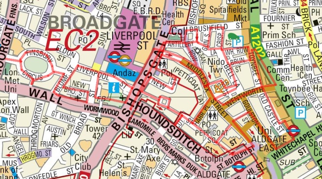
Today’s journey’s a little bit different from the usual in that it coincided with the Sunday of this year’s Open House Weekend so I was afforded the possibility of seeing inside a few places en route that would normally be off limits. Case in point is the Drapers’ Hall which we encountered towards the end of Day 44 so we’re going to rewind a bit and kick off with that again this time. From there we’re going to head north up to London Wall then drop south on Bishopsgate to Leadenhall Market before wending our way east and south to finish up at the Monument.

Day 45 Route

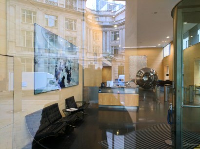
As noted, today’s starting point is the Drapers’ Hall on Throgmorton Street. We already covered the history of the Drapers’ Company and the external architectural features last time out so I’m just going to let the images of the interior pretty much speak for themselves (aside from the commentary I’ve added to the individual slides that is). Suffice to say, I had expected something pretty grandiose as befitting third place on the Order of Precedence but I wasn’t prepared for something quite this opulent (and on such a scale).

This slideshow requires JavaScript.

You will have noted that the Victorian artist, Herbert James Draper (1863 – 1920) had quite a prominent role in in the decoration of the Hall. Whether he got the commission on account of his name or because the guiding lights of the company appreciated his somewhat risqué interpretations of mythological and Shakespearean themes is not recorded (so far as I can tell). The thinking behind the tapestries and ceiling painting depicting scenes from the Legend of Jason and the Golden Fleece is rather easier to discern.

After leaving the hall we repeat the walk up Throgmorton Avenue to Austin Friars which leads east to the Dutch Church. Originally this was the site of a 13th century Augustinian priory (Austin Friars) before, in 1550, what is regarded as the oldest Dutch-language Protestant church in the world church was founded here. That first building survived right up until the Blitz destroyed it; the present church was built in the early 1950’s. Perkin Walbeck, the pretender to the English crown (he claimed to be the younger son of Edward IV, one of the Princes in the Tower murdered by Richard III), was buried in the original church following his execution by Henry VII. Today the church still acts as a focal point for the Dutch community in London.

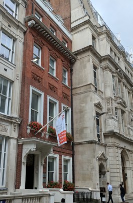
Opposite the church is the Furniture Makers’ Hall – which is the one that I could claim entry to by virtue of ancestry. Typical ! If only my Grand-dads had been drapers instead of chairmakers.

IMG_20170823_163832

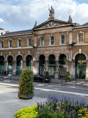
Looping round the rest of Austin Friars we emerge onto Old Broad Street opposite the City of London Club, the oldest Gentlemen’s club in, well, the City of London. This was founded in 1832 by a group of prominent bankers, merchants and ship owners and held its first meetings at the George and Vulture pub (see last post). The original membership numbered 600 and included the Duke of Wellington and Sir Robert Peel. If you should want to join then you need to make the acquaintance and get the support of at least six people who are already members (and ladies are equally welcome these days apparently).

IMG_20170823_164020

As you can see, these days the City of London Club, sits in the shadow of Tower 42, which until 1990 and the construction of One Canada Square at Canary Wharf was the tallest building in the UK. Nowadays it’s only the third highest skyscraper in the City of London having been eclipsed in recent years by the Heron Tower (we’ll stick with that name thank you) and 122 Leadenhall Street (a.k.a “the Cheesegrater”). Tower 42, of course, started life as the NatWest Tower (seen from above the shape of the building echoes the NatWest logo). It was designed by Richard Seifert (1910 – 20011) and built by John Mowlem & Co between 1971 and 1980 at a cost of £72m. At 183m the tower dwarfed everything around it at the time of construction and was extremely controversial. It was built around a massive central concrete core from which the floors are cantilevered (anchored at just one end) making it exceptionally strong but reducing the amount of office space that could have been available with an alternative structure. On a note with contemporary resonance; at the time of design, fire sprinkler systems were not mandatory in the UK and so weren’t installed. It was this omission, coupled with a fire in the tower during a 1996 refurbishment, that prompted the GLC to amend its fire regulations and require sprinkler installations in all buildings. Today the building is multi-tenanted with a high-end restaurant on the 24th floor and a champagne and seafood bar on the 42nd.

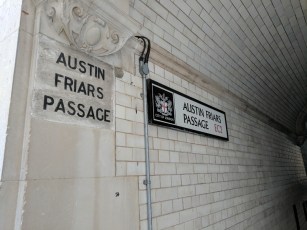
Moving on we duck into Pinners Alley (by the side of Pinners Hall where I worked from 1996 to 2004) heading west briefly before turning north up Austin Friars Passage – which I always though should’ve been the name of a second division 1970’s pro-rock band.

IMG_20170823_164254

At the other end is Great Winchester Street which is home to Deutsche Bank’s London HQ. Among the artworks in their lobby is one of Damien Hirst’s multi-coloured dot efforts (more of him later).

IMG_20170917_115458

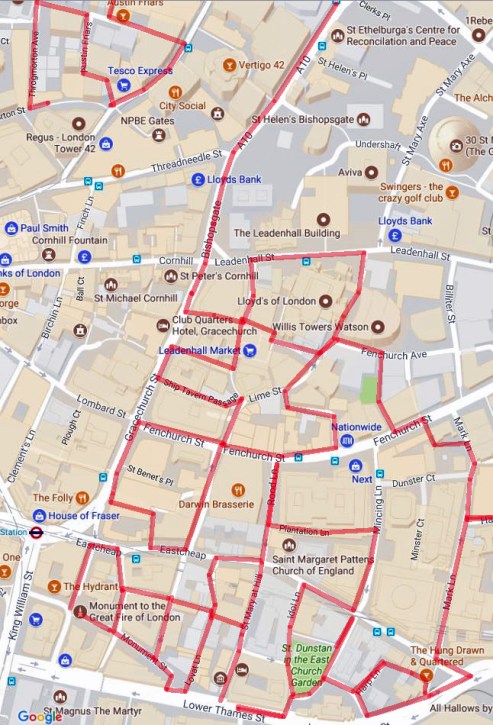
Turning left we end up back on London Wall which as we head east morphs into Wormwood Street. At the junction with Bishopsgate (a.k.a the A10) we switch southward and drop all the way down to Leadenhall Market. On the way we pass a NatWest building of a different vintage altogether; this one built in the 1860’s to a design of the architect John Gibson (1817 – 1892) when the bank was known as the National Provincial Bank of England.

At Leadenhall Market I was able to tag along with a tour that had just started (courtesy of Open House again). I wish I had made a note of the guide’s name so I could give a well deserved shout-out as she was excellent. Anyway, Leadenhall Market dates back to the 14th century and stands on a site that was once the heart of Roman London. As early as 1321 it was a meeting place of the Poulterers while the Cheesemongers (I think we must have missed them on our travels) sold their wares here from 1397. In 1411 the Corporation of London acquired the freehold of the site and it became an established market for fish, meat, poultry and corn. The present wrought iron and glass roofed structure was designed by City Architect, Horace Jones (1819 – 1887) and erected in 1881. The Market has been used as a location in a number of films, most notably Harry Potter and the Philosopher’s Stone where it represented Diagon Alley and the Leaky Cauldron pub.

This slideshow requires JavaScript.

We leave the market via Whittington Avenue and, turning right on Leadenhall Street, pass the Lloyds of London building (not to be confused with the Lloyds Register building which we encountered previously). This iconic, Richard Rogers designed edifice, caused even more of a stir when it was put up (between 1978 and 1986) than the NatWest Tower had. In spite of this, 25 years after its completion it became the youngest structure ever to be granted Grade-I listed status. Lloyds is a leading example of what has been dubbed Bowellism, the practice of putting service areas of a building on its exterior so as to maximise space in the interior (c.f. Paris’s Pompidou Centre). The building consists of three main towers and three service towers around a central, rectangular space. Its core is the large Underwriting Room on the ground floor, which houses the Lutine Bell within the Rostrum. (It wasn’t taking part in Open House this year but the queues are normally prohibitive anyway).

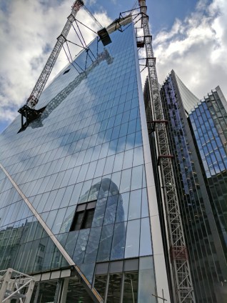
The Lloyd’s building is at no.1 Lime Street; opposite at no.52 construction is underway of yet another skyscraper, The Scalpel. This time that’s an official designation, the developers yielding to the “if you can’t beat ’em join ’em” maxim. This one will top out at 38 storeys and be the new European HQ for insurers W.R Berkley (no me neither).

IMG_20170917_123428

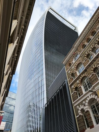
Turn south down Lime Street and then return to the Market along Leadenhall Place. Take a left into Lime Street Passage and then traverse the Market a couple more times via Beehive Passage, Bull’s Head Passage and Ship Tavern Passage. This finds us back on Lime Street which we follow southward to Fenchurch Street. From here we go west back to Gracechurch Street then continue south before cutting round Talbot Court down onto Eastcheap. Turn east as far as Philpot Lane and use this to return northward, poking our noses into Brabant Court on the west side before arriving back on Fenchurch Street. This route takes us around no.20 Fenchurch Street, better known to you, me and everyone else as the “Walkie-Talkie” and the 2015 winner of Building Design Magazine’s Carbuncle Cup for the worst building in the UK. It is notorious of course because its concave shape makes it reflect sunlight into a concentrated beam that on reaching street level has been known to melt the bodywork of parked cars and facilitate the frying of eggs on the pavement. Those incidents took place in 2013, since when the glass exterior has been covered with a non-reflective film. In an interview with The Guardian the building’s architect, Rafael Vinoly, blamed the problem on global warming “When I first came to London years ago, it wasn’t like this … Now you have all these sunny days”.  The ‘sky garden’ at the top of the building was claimed to be London’s highest public park, but since opening there have been debates about whether it can be described as a ‘park’, and whether it is truly ‘public’ given the access restrictions. On the day there was a queue of about eighty or so people waiting to be allowed up.

IMG_20170917_124732

This time we strike eastward until we reach Cullum Street which curves back onto Lime Street. At the junction here that man Damien Hirst makes a second appearance in today’s post, lowering the tone of the neighbourhood with one of his giant anatomical models as part of Sculpture in the City.

IMG_20170917_123920

This time we make an easterly retreat from Lime Street along Fenchurch Avenue and after a short distance cut back to Fenchurch Street via Fen Court. There is a small garden here in what was once the churchyard of St Gabriel Fenchurch, lost in the Great Fire. The sculpture “The Gilt of Cain” by Michael Vissochi was unveiled by Archbishop Desmond Tutu in 2008 and commemorates the 200th anniversary of the abolition of the transatlantic slave trade. It takes its name from a poem of Lemn Sissay which is inscribed on the sculpture and combines Old Testament text with the language of the Stock Exchange.

You’re probably wondering by now where all the churches had got to but don’t worry, there are one or two on the menu today – though fewer than you’ve had to put up with in the last few posts. First up is All Hallows Staining which we reach by taking Star Alley south from Fenchurch Street through to Mark Lane. Mind you, all that remains of this one is its tower which was built around 1320 AD. The rest was demolished c.1870 when All Hallows merged with nearby St Olave Hart Street (see Day 40). The latter was badly damaged in WW2 so a prefab church was erected next to the tower and named St Olave Mark Lane (as you see the sign in the photo confusingly still refers to St Olave). The tower is maintained by the Worshipful Company of Clothworkers, whose hall sits in nearby Mincing Lane.

IMG_20170917_132720

Next we follow Mark Lane down to Great Tower Street which at its eastern extremity adjoins with Byward Street which as it heads west turns into Lower Thames Street. At the juncture here sits The Hung Drawn & Quartered pub which acts as a reminder of the public executions which once took place on nearby Tower Hill, including those of Thomases More and Cromwell.

IMG_20170917_133151

We leave Lower Thames Street almost immediately and wend our way through Bakers Hall Court, Harp Lane and Cross Lane to St Dunstan’s Hill where lie the ruins of the church of St Dunstan in the East, now set within a public garden that was laid out in 1967. St Dunstan’s wasn’t completely destroyed in the Great Fire so it was patched up in the immediate aftermath and then a Wren-designed tower and steeple were added at the end of the 17th century. Apart from a couple of walls this tower was all that remained intact after the WW2 bombing and it was decided not to rebuild again. Personally I like it as it is now – as do the birds.

This slideshow requires JavaScript.

Dropping back down onto Lower Thames Street it’s time for another Open House visit – to the Billingsgate Roman House and Baths (or rather the very partial remains thereof) located beneath a drab 1980’s office block. Discovered in 1848 during the construction of the Coal Exchange building (more of that in a while) these are the only remains of a Roman house accessible in London. It is believed that the house was originally built around the late 2nd century AD and the baths added in the following century. The latest theory is that at the time the baths were constructed the building had become a resting-place for travellers, essentially a Roman version of a hotel. I have to again commend the guides who were exceptionally informative and engaging. Visits to the site are restricted but you can book a tour through the Museum of London outside of Open House weekend.

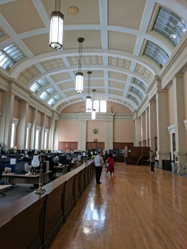
Opposite here, straddling the area between Lower Thames Street and the river is another Open House destination, Custom House. An English Customs service on an ad hoc basis has existed since at least the middle of the 8th century and was formalised by King Edward I in 1275 as a means of beefing up the royal finances. The current Custom House is thought to be the fifth such to have been built on this site, chosen because beyond this point London Bridge has historically prevented ships from going further upriver. The present building was put up between 1813 and 1817 and initially designed by David Laing (1774 – 1856), Surveyor to the Customs. However within a few years of completion the ceiling of the Long Room had partially collapsed and the floor completely given way. The latter event occurred just a day after Sir Robert Smirke (1780 – 1867) had concluded an inspection of the premises and advised staff to evacuate. Smirke was then engaged to oversee the rebuilding and Laing’s career suffered the same fate as the floor. The Custom House now comprises a west wing built by Laing, a central block built by Smirke and an east wing dating from 1962-66. The southern façade, made of Portland stone, is much more aesthetically-pleasing than the northern face of yellow stock brick; this is because the building was designed to be seen from the river and impress shipfarers from overseas.

This slideshow requires JavaScript.

The Great Long Room was an innovation of Christopher Wren (prolific doesn’t even begin to do the man justice) for his version of the Custom House, built in 1671. This was to be the public room where all import and export business was to be transacted. Because of this room, the public rooms in Custom Houses around the world have become known as ‘Long Rooms’ irrespective of their shape or size. The current Long Room is the work of the aforementioned Sir Robert Smirke, it is 190 feet long and 63 feet wide and has one of the largest unsupported wooden ceilings in Europe.

IMG_20170917_151631
The Long Room

The Coal Exchange which I mentioned earlier was one of the glories of Victorian Architecture, built in 1847-49 to the designs of City architect, James Bunstone Bunning (1802 – 1863) and opened to great fanfare by Queen Vic herself. The interior was one of the earliest and most remarkable examples of cast-iron construction in the world, several years before the Crystal Palace. However that didn’t cut any ice with the town planners of the 1960’s who had little regard for Victorian extravagance. Despite the objections of the Victorian Society and Sir John Betjeman (naturally) the building was demolished in 1962 in preparation for a road-widening scheme that didn’t actually take place until the 1980s. Why do I mention this ? Because the alternative would have been to shave off that unlovely north face of the Custom House, an option which from a 21st century perspective appears immeasurably more appealing.

Coal Exchange

James Bunning was also responsible for the original Billingsgate Fish Market built just to west of the Custom House in 1850 but rendered obsolete by increased levels of trade within 25 years. Work on a new market building, designed by Horace Jones in the Italianate style, began in 1874 and was completed three years later. In 1982 the fish market was relocated to the Isle of Dogs and the building on Lower Thames Street was refurbished under the guidance of Richard Rogers (he gets about a bit as well). The Grade II listed building is now used as an events venue.

IMG_20170917_153833

Time we got moving again I think. Head up Idol Lane which runs to the west of St Dunstan’s and turn right on Great Tower Street before proceeding north (with a manly stride) up Mincing Lane. Next move is west along Plantation Lane which leads into Rood Lane. Venture northward first before doubling back towards Eastcheap. On the corner here stands the Guild church of St Margaret Pattens (unlike Parish churches Guild churches hold regular weekday services rather than serving a Sunday congregation). The church’s exterior is notable for its 200-ft high spire, Wren’s third highest and the only one that he designed in a medieval style. The name of the church derives from pattens, wooden-soled overshoes which historically enabled Londoners to walk about the city without sinking too deep into the mud and effluent which covered the streets. The church still has an affiliation with the Worshipful Company of Pattenmakers.

IMG_20170917_153041

Cross over Eastcheap and drop down St Mary at Hill back towards the river. At no.18 we find the Watermen’s Hall, home to the Company of Watermen and Lightermen (in a riverfaring context the Watermen were the equivalent of taxi-drivers and the Lightermen the truckers). The hall was built in 1780 by William Blackburn and is the only remaining Georgian hall in the City of London. The Watermen are not a Livery Company as such, hence no Worshipful before the name. This is because the Waterman are governed by statutes and Royal Charters that extend beyond the boundaries of the City of London. So unlike the Pattenmakers (no.70) they don’t appear in the Order of Precedence.IMG_20170917_153709

So we’re almost at our final stop and to get there we have to negotiate as follows: north up Lovat Lane, left turn into Botolph Alley, north up Botolph Lane, west along Eastcheap, south down Pudding Lane, left along St George’s Lane back to Botolph Lane, south this time and then west into Monument Street. Which, as you might have guessed, brings us to The Monument itself. As I’m sure you’re aware, this was erected in commemoration of the Great Fire of 1666 and the subsequent rebuilding of the City and was completed in 1677. The fire was alleged to have begun in a baker’s shop on Pudding Lane and the height of The Monument is equal to its distance from that starting point, 202 feet. The designers of the memorial were Sir Christopher Wren (goes without saying really) and his friend Dr Robert Hooke (1635 – 1703). They came up with the idea of a classic Doric column with 311 steps up to a viewing platform and a summit topped with a drum and copper urn from which flames emerge. A total of seven people died falling from the viewing gallery (six suicides and one who accidentally fell after leaning over the balcony to look at a live eagle kept in a cage) before it was enclosed in an iron cage in 1842. It costs £5 (cash only) if you want to ascend up to the platform.

Keeping my five pounds in my pocket I walk on by and finish today’s epic with a stroll up and down Fish Street Hill.

And that’s us finally just about done with the City of London. Next time we’ll be heading back west over to Hyde Park for a complete change of scene.


Day 40 – Aldgate – Tower Hill – Fenchurch Street

Shifting slightly further to the east for this excursion which starts out where we left off a couple of months back on Aldgate High Street then heads south down to Tower Hill, stopping short of the Tower itself, before snaking west and north through the City. Because this walk took place on Easter Sunday the area was atypically quiet apart from the inevitable tourist throng near the Tower and, less obviously, in the vicinity of the Gherkin.

Day 40 Route

So we set out on Aldgate High Street  opposite Aldgate tube station and proceed south down Little Somerset Street. Looking behind us gives a background glimpse of what’s to come later.

IMG_20170416_112536

Reaching Mansell Street we continue south turn right along Haydon Street and then when this adjoins onto the Minories head northward to return to Aldgate High Street opposite the church of St Botolph without Aldgate. This is the second time we’ve encountered St Botolph; he was “without Bishopsgate” a few posts back. In fact there were four medieval churches built in London in honour of this particular saint, all of which stood by one of the gates of the London Wall (more of that later). Aldersgate is the other one of those that survives while the church at Billingsgate wasn’t rebuilt after the Great Fire. St Botolph’s was often referred to as the “Church of Prostitutes” in the late Victorian period. To escape arrest by the police the local ladies of the night would parade around the island in a sea of roadways on which the church stands.

IMG_20170416_113557

Turn south again, this time down Jewry Street which is the site of the Sir John Cass Foundation. John Cass (1661 – 1718) was both a Sheriff and Alderman of the City of London and in 1710 set up a school for 50 boys and 40 girls which originally occupied buildings in the churchyard.  After his death, despite his will being incomplete and contested, his wish to leave the majority of his estate to the school was upheld though it took thirty years. So the Foundation came into being in 1748 and in 1899 a Technical Institute was created alongside the school and this moved into the new-build premises on Jewry Street, becoming the Sir John Cass College in 1950.

After nipping briefly into Saracens Head Yard we take the next right turn, Carlisle Avenue, which takes us into Northumberland Alley which meets its end at the wonderfully-named Crutched Friars. Crutched Friars is one of the alternative names of the Roman Catholic order Fratres Cruciferi (Cross-bearing brethren). Crutched refers to the crucifix-surmounted staff which they carried about with them. Next up, turning north again, is Rangoon Street, which is barely more than an alcove, before we switch eastward down India Street. Turn right next down Vine Street (not the one which forms part of the Orange set of properties in Monopoly – that’s over near Piccadilly) then veer off to the left, down Crosswall which takes us into Portsoken Street. This latter skirts one side of a charming small park wedged in amongst some less than charming buildings.

IMG_20170416_114946

At the end of Portsoken Street we swing round Mansell Street and Goodman’s Yard to loop back onto Minories and then turn south under the railway bridge and past Tower Gateway station, one of the two western termini of the DLR.

IMG_20170416_115538

So we’re now onto Tower Hill and moving west parallel to the north side of the Tower of London. Here there is one of the most substantial surviving sections of the London Wall built around the city  by the Romans in around 200 AD. In total the wall was about 4km long enclosing some 330 acres and including the four city gates (mentioned previously) with a further entrance to the legionary fortress at Cripplegate.

Turn north into Cooper’s Row and head up past Trinity Square Gardens back to Crosswall (whose name now makes perfect sense). Duck through American Square onto the southern section of Vine Street which seems to lead nowhere but then suddenly and bizarrely emerges into a crescent of replica Georgian houses (some rebuilt immediately post WW2 others as part of a 1980s redevelopment) called, simply and literally, Crescent.

IMG_20170416_120510

Double back and cut through a series of alleyways leading out onto Cooper’s Row again. Cross over and proceed west along Pepys Street before turning south down Savage Gardens. This returns us to Trinity Square, to No. 10 Trinity Square in fact, which links neatly back to the previous post for this is the first permanent HQ of the Port of London Authority. It was built in the Beaux Arts style by John Mowlem & Co to a design of Sir Edwin Cooper and was opened by then Prime Minister, David Lloyd-George, in 1922. The façade of the building is interspersed with Corinthian columns and high above the front entrance is a sculpture of Old Father Thames, holding his trident and pointing east in homage to the trade between nations. In 1946 the General Assembly of the United Nations held its inaugural reception here, in what is now known as the UN ballroom. In the 1970’s the PLA moved out to Tilbury and no. 10 was renovated; becoming the home of insurance broker Willis Faber until 2008. Two years after they left a Chinese Investment company bought the Grade II-listed building and after a six year multi-million pound renovation it was brought back to life as a Four Seasons Hotel. In the interim it had a walk-on part in the James Bond Skyfall film as a location for a meeting between M (Dame Judi Dench) and Gareth Mallory (Ralph Fiennes).

This slideshow requires JavaScript.

Moving on clockwise round the square we come first to Trinity House which is the home of the organisation that began life as The Corporation of Trinity House (or to give it its full name The Master Wardens and Assistants of the Guild Fraternity or Brotherhood of the Most Glorious and Undivided Trinity and of Saint Clement in the Parish of Deptford Strond in the County of Kent), under Royal Charter of 1514 with a remit to regulate pilotage on the River Thames and provide for aged mariners. Today Trinity House is the UK’s largest maritime charity dedicated to safeguarding shipping and seafarers as well as incorporating the General Lighthouse Authority (GLA) for England & Wales. The GLA is responsible for a range of aids to navigation from lighthouses to radar beacons but, confusingly, is separate from HM Coastguard (which looks after all aspects of search and rescue).

The building itself dates to 1796 and was designed by architect Samuel Wyatt.

IMG_20170416_121211

On the east of the square at no.43 is a blue plaque commemorating Reverend Philip “Tubby” Clayton (1885 – 1972), founder of the international Christian movement Toc H. And next door at no.41 is a memorial to Viscount Wakefield of Hythe (1859 – 1941) who founded the Castrol lubricants company and was a Lord Mayor of London and also Tubby’s mate.

IMG_20170416_121349

We now take a stroll through Trinity Square Gardens which is dominated by the Merchant Navy Memorial. The original, post WW1, section was designed by Sir Edwin Lutyens with sculpture by Sir William Reid-Dick and was unveiled by Queen Mary on 12 December 1928.  It commemorates almost 12,000 Mercantile Marine casualties who have no grave but the sea, including almost 1,200 lost when the Lusitania was sunk in 1915. The WW2 extension, which commemorates almost 24,000 casualties, was designed by Sir Edward Maufe, with sculpture by Charles Wheeler and was unveiled by Queen Elizabeth II on 5 November 1955.

This slideshow requires JavaScript.

Leaving the gardens on the west side we find ourselves back outside Ten Trinity Square, which as I mentioned is now a Four Seasons hotel having opened a mere three months back in January 2017. On impulse born of curiosity I decide to head inside for a lunchtime cocktail at the Rotunda bar. I have the place to myself pretty much and the very amiable bartender rustles me up a concoction called (appropriately) a Shivering Timbers which will set me back £15 plus service. Still it’s just about worth it to take in the elaborately refurbished interior (and make a luxurious and desperately need toilet stop). As well as the hotel the building incorporates 41 private residences and a private members’ club. At the time of speaking £440 a night for the cheapest room doesn’t include access to the spa and swimming pool as these won’t be open for a few more weeks.

This slideshow requires JavaScript.

Leaving the hotel, head west along Muscovy Street and then turn north up Seething Lane before returning eastward along Pepys Street and via another section of Savage Gardens find ourselves back on Crutched Friars. From here we continue north up Lloyds Avenue most of the buildings on which were built under a redevelopment of derelict East India Company warehouses at the turn of the 20th century. Coronation House at no. 4, built in 1904,  eventually became absorbed into the Lloyd’s Register building which stood on the corner with Fenchurch Street.

IMG_20170416_131130

Lloyd’s Register (not to be confused with Lloyds of London) began life in 1760 in a London coffee house as a marine classification society. Nowadays it operates as a global provider of risk assessment and technical consultancy services across numerous industrial sectors but is still wholly owned by the charitable Lloyd’s Register Foundation.

It moved into the premises at 71 Fenchurch Street, designed by Thomas Colcutt, in 1901. Almost 100 years later it moved again – just a few yards further along Fenchurch Street – to a glass, steel and concrete skyscraper designed by the Richard Rogers Partnership (who of course had previously been responsible for the much better known Lloyd’s of London building – of which we shall hear more another time).

We’re going east again now on Fenchurch Street and at the junction with Leadenhall Street where it turns into Aldgate High Street we find the Aldgate Pump. This historic water pump, which has stood on this spot since 1876, marks the start of the A11 road that eventually leads to Norwich. It’s also considered by many to be the symbolic start of the East End. The wolf’s head is supposed to commemorate the last wolf shot in the City of London though there appears to be no record of when that might have been.

IMG_20170416_131442

Moving on we make a sharp left into Mitre Street and then cut through St James’s Passage to join Dukes Place. Turn the corner and we’re on to Houndsditch. Head up here as far as Creechurch Lane which we follow back across Dukes Place as far as the junction with Heanage Lane which we take back up to Bevis Marks (which Dukes Place merges into and which gets several mentions in Dickens’s Old Curiosity Shop). From here we take the next right, going north, Goring Street to return to Houndsditch. Turn left then left again down the top section of St Mary Axe to revisit Bevis Marks. Turn south this time and then loop round Bury Street past Cunard Place and back onto the lower stretch of Creechurch Lane. Here on the corner with Leadenhall Street stands the actual Cree Church, the Church of St Katharine Cree to be precise. The church was founded in 1280 and the present building dates from around 1630. It is the only remaining Jacobean church in London having survived both the Great Fire and the Blitz practically unscathed.

IMG_20170416_133106

Crossing over Leadenhall Street we squeeze through the alley known as Fenchurch Buildings and having traversed Fenchurch Street again navigate a couple more alleys in the form of St Katharine’s Row and French Ordinary Court which take us round the back of Fenchurch Street Station and onto Hart Street. Turning west we reach another medieval church that eluded the clutches of the Great Fire, St Olaves. This one dates all the way back to 1450 in its present form (more or less – it wasn’t so lucky in the Blitz and had to be extensively restored after the war). The fabulously macabre entrance to the churchyard was a 1658 addition. The church is dedicated to the patron saint of Norway, King Olaf II and the Norwegian connection continued during and after WW2 when King Haakon VII of Norway worshipped here in exile and then in 1954 presided over the rededication ceremony. Samuel Pepys was buried here in 1703 and it is also, weirdly, recorded as the last resting place of the pantomime character Mother Goose (?). Her internment apparently took place in 1586 according to the parish registers and the event is commemorated by a plaque on the outside of the church.

This slideshow requires JavaScript.

Leaving St Olaves behind we move northward again next, up New London Street into London Street (both doing less than nothing to deserve such names) and round Fenchurch Place to the front of Fenchurch Street Station, gateway to Essex. The station opened in 1841 initially to serve the London and Blackwall Railway but was reconstructed after just 13 years when the London, Tilbury and Southend Railway began operations. It’s one of the smallest termini in London and uniquely has no interchange with the underground.

IMG_20170416_134003

Back on Fenchurch Street we continue west for a bit and then proceed north up Billeter Street resurfacing on Leadenhall Street. Keep the westerly trajectory before turning north again up the bottom-most section of St Mary Axe. On the right here is yet another of the City churches that survived the double whammy of the Great Fire and the Blitz. The present St Andrew Undershaft was built in 1532 in the Perpendicular style (a subdivision of Gothic, so-called because of its fondness for vertical lines). The church’s name derived from the shaft of the maypole that was set up opposite the church – though only until 1547 when it was seized by a mob and destroyed as a “pagan idol” (now that’s a show I’d like to see).

IMG_20170416_134926

Continuing north we arrive at the foot of St Mary Axe’s most famous resident, no. 30 more commonly known as “The Gherkin”.  The Gherkin, designed and engineered by Norman Foster and Partners and the Arup Group respectively, was completed in December 2003 and opened in April 2004. 41 storeys and 180 metres tall, it stands on the site of the former Baltic Exchange which was irretrievably damaged by the IRA bomb of 1992. It has a floor area of just over half a million square feet including a restaurant on the 39th floor. In November 2014 the building was bought by the Safra Group, controlled by the Brazilian billionaire Joseph Safra, for £700m (£150m than the price originally anticipated). The sculpted head you can see below is another work in the Sculpture in the City 2016 series; “Laura” by Jaume Plensa.

This slideshow requires JavaScript.

After a circuit round the base of the Gherkin we meander off to the west again down the dead end that is Undershaft. Doubling back and then turning left down Great St Helens we pass in front of St Helen’s Bishopsgate which, you’ve guessed it, also survived the Great Fire and the Blitz (it’s almost like there was some kind of divine providence at work here). Wasn’t so fortunate when it came to that IRA bomb in 1992 however; that took the roof off and also destroyed one of the City’s largest medieval stained glass windows. The church started out as a priory for Benedictine nuns in the early 13th century and was Shakespeare’s parish church when he lived in the area in the 1590s. The artwork on display outside the church, Shan Hur’s “Broken Pillar #12” has been left in place from the 2015 Sculpture in the City collection.

This slideshow requires JavaScript.

At the end of Great St Helens we emerge onto Bishopsgate and head north towards Liverpool Street station. Final point of interest on today’s journey stands at no.110 bounded on its other three sides by Camomile Street, Outwich Street and Houndsditch. Completed in 2011 the building was originally known as the Heron Tower after its owners Heron International but in 2014 its primary tenant pressed for the name to be changed to the pitifully naff Salesforce Tower. The City of London eventually ruled that it should officially be called simply 110 Bishopsgate. Whatever its name the building stands 230 metres tall (including the 28 metre mast) with 46 floors. It currently holds the record as the City of London’s tallest structure, having eclipsed Tower 42 when construction reached the 44th floor.

Situated on floors 38 and 39, Sushi Samba restaurant is one of the top restaurant destinations for the young, aspiring (and easily impressed) denizens of the Home Counties and for those without a head for heights, the lobby contains a 70,000 litre aquarium.

IMG_20170416_134711

And I think that’s us finally done for this time around (and I really expected this one would reverse the trend for longer and longer posts).


Day 34 – Bishopsgate – Middlesex Street – Finsbury Circus

Today’s walk sees us back east again; first of all south of Spitalfields in the streets taken over by the stalls of Petticoat Lane market then skirting Aldgate before heading back into the City across Bishopsgate and west into Finsbury Circus.

day-34-route

We kick things off on Liverpool Street, which runs south of the eponymous mainline station. This takes us into Bishopsgate where, passing the front entrance of the station and crossing the road, we arrive at the Bishopsgate Institute.  Since the 1st of January 1895, when it was established using funds from charitable endowments made to the parish of St Botolph without Bishopsgate, the Institute has operated as a public library, public hall and meeting place for people living and working in the City of London. The architect behind this now Grade II-listed building with its elements of styles ranging from Byzantine to Art Nouveau was Charles Harrison Townsend (1851-1928). Today, in addition to being a venue for a disparate selection of cultural events, the Institute is best known for its adult education course covering over 120 different subjects.

p1060200

Turning right down Artillery Lane we head into the area between Bishopsgate and Commercial Street which is a twilight mix of the rapidly vanishing old East End and new upscale development. Dip in and out of Brushfield Street (which borders Spitalfields) using Fort Street, Stewart Street and Gun Street before heading further south down Crispin Street. On the east side here is a massive new development on the site of the old Fruit and Wool Exchange, something else we have our old friend Boris Johnson to thank for. On the other side of the street the historic painted signwriting for the Donovan Brothers paper bag making business, which they set up here in the 1830’s, still survives. As does the family business itself though it now operates out of the New Spitalfields Market in Leyton.

p1060202

A couple of doors along is Lilian Knowles House which now provides accommodation for post-graduate students of the LSE and is named after a former Professor of Economic History but was once the Providence Row night refuge for homeless women and children. Anecdotally, it is believed that Jack the Ripper’s final victim, Mary Jane Kelly, lived and worked here – she was found murdered in a nearby alley which no longer exists.

p1060203

From here we turn east down White’s Row then dip briefly south down Toynbee Street before taking a right into Brune Street. On the corner here is the Duke of Wellington pub which I mention because (a) it’s one of the few pubs in this part of the world that has a beer garden (of sorts), when I worked in the City we would occasionally trek all the way over here in the summer for that reason alone and (b) I’m surprised it’s still here.

p1060205

On the north side of Brune Street is the ceramic-tiled facade of the soup kitchen established here in 1902 to serve impoverished members of the local Jewish community. Amazingly, the facility existed right up until 1992. In earlier times it was providing groceries to up to 1,500 people a day.

p1060206

After a quick visit to Tenter Ground, at the end of Brune Street we turn left down Bell Lane then right into Cobb Street and right again into Leyden Street. On the bend where this turns into Strype Street is tucked away the 1938-built Brody House, a rare surviving example of thirties architecture in this part of town. The street itself was named after the clergyman and historian John Strype (1643 – 1737 good innings !) who in 1720 produced a new survey of London which revised and expanded the pre-Great Fire original by John Stowe (1525 – 1605) published in 1598.

Next we’re out onto Middlesex Street and bang in the midst of Petticoat Lane Market. There has been a clothing market here, in the heart of the area that has been home to the various iterations of the garment industry for centuries, since the mid 1700’s. And the name of the market has endured even though the street ceased to be called Peticote (or Petticotte) Lane in the reign of William IV c.1830. Today the Middlesex Street section of the market is only open on Sundays (this walk took place on a Sunday) whereas the Wentworth Street stalls are in situ six days a week. It’s still predominantly clothing up for sale and the majority of vendors and customers these days are drawn from the local Bangladeshi community. It’s remains a vibrant place but (and it’s hard to avoid being snotty about it) the merchandise on offer is basically an ocean of tat.

This slideshow requires JavaScript.

Check in on the remaining section of Cobb Street then navigate the Wentworth Street section of the market before turning northward into Toynbee Street with its unkempt charms and note of blind faith (see left side of top right photo).

At the apex with Commercial Street we turn south again past a welcome nostalgia tug in the form of a graffiti-ed Snagglepuss. Out of the same Hanna Barbera stable as Yogi Bear, Snagglepuss actually appeared first in the Quick Draw McGraw Cartoon Show in 1959 (so he’s precisely the same vintage as me). “Heavens to Murgatroyd!”

p1060220

Turn back into Wentworth Street and then continue south towards Aldgate East via Old Castle Street, Pommel Way and Tyne Street. On the former is a vestige of the Public Wash House that was completed in 1846 and construction of which therefore started prior to the passing of the Baths and Washhouses Act by parliament in the same year. That was down to the “Committee for Promoting the Establishment of Baths and Wash-Houses for the Labouring Classes” founded in 1844 under Robert Cotton, the then Governor of the Bank of England.

p1060224

Moving on we head back towards the market up Goulston Street where these pigeons seem blissfully unaware of the danger lurking in the background;

p1060225

before cutting west down New Goulston Street which has some more striking street art. The rat crawling out of the brickwork is by graffiti artist ROA, and the horror themed building facade was created by Zabou specifically for Halloween 2016.

p1060226

Then we’re back on Middlesex Street again and turning south down towards Aldgate again we stop in the shadow of this condemned sixties’ block and turn the corner into St Botolph Street. St Botolph, the patron saint of wayfarers, lived and founded a monastery in East Anglia in the 7th century. Unusually for a Saint he lived to a ripe old age and died of natural causes.

p1060227

Nothing special about this other than the fact that it’s pretty much the last man standing in terms of the post-war concrete boxes round here being demolished and their sites redeveloped. Next up, in rapid succession, we traverse Stoney Lane, White Kennett Street (named after an 18th century Bishop of Peterborough), Gravel Lane and Harrow Place. This funky fire escape brings the next pause for breath at the end of Clothier St cul-de-sac.

p1060228

Cutler Street, which was once the site of the largest tea warehouse in the city, leads into Devonshire Square. Rather confusingly this is both the name of the road feeding into and the original Georgian square itself and also the name of the mammoth 2006 office, retail and residential redevelopment of the Cutler Gardens Estate (land owned by the East India Company back in the day). Even further back than that, the end of the 10th century in fact, the land was supposedly given by King Edgar to thirteen of his knights on condition of them each performing three duels; one on land, one below ground and one on water. Sounds pretty apocryphal to me but the creator of this work on the edge of one of the courtyards was obviously a believer.

The original square is the site of Coopers Hall home to the smallest of the London Livery Companies, The Worshipful Company of Coopers. The origins of this Company go back to the 11th century, barrel-making being one of the oldest of all the trades I guess. Not one of the most highly respected though unfortunately; apparently there is a hierarchy of Livery Companies and the Coopers only rank 36th.

p1060233

From the square we loop round Barbon Alley and Cavendish Court to arrive in Devonshire Row which takes us back into Bishopsgate. On the way the spaces created by impending new developments allow for some interesting views of the ones that have recently been completed.

Turn north on Bishopsgate then east along New Street which dog-legs left and then merges into Cock Hill. At the top here we turn left into the highly insalubrious Catherine Wheel Alley which snakes back to Bishopsgate. This is named after the Catherine Wheel pub, which was reputedly the haunt of notorious highwayman thief Dick Turpin, and stood for more than 300 years before it was demolished in 1911. The name of the pub derives from the instrument of torturous execution linked with the martyrdom of Saint Catherine of Alexandria in the 4th century. Consequently, the name of the alley was briefly changed at one point to Cat and Wheel Alley in order to placate Puritans who objected to the association of a filthy, crime-ridden alley with a martyred saint.

p1060237

Swiftly moving on, we finish off the rest of Middlesex Street then do a circuit of Sandy’s Row, Frying Pan Alley and Widegate Street before returning once more to Bishopsgate. Frying Pan Alley, perhaps unremarkably, gets its name because it once housed a shop selling pots and pans that had a huge cast iron frying pan suspended from chains as its sign.

We’re crossing over Bishopsgate next and heading south past Liverpool Street Station again. We turn right into Bishopsgate Churchyard which actually runs through the churchyard of the Church of St Botolph without Bishopsgate. As is so often the case it seems, the presence of a church on this site dates back to Saxon age. The original Saxon church was replaced twice, with the third version even surviving the Great Fire, before that was demolished in 1725, and the present church was completed four years later to the designs of James Gould, under the supervision of George Dance (the Elder). It is aisled and galleried in the classic style, and is unique among the City churches in having its tower at the East End, with the chancel underneath. Having got through WWII with the loss of just one window, the church fared less well during the IRA bombing campaign of the early 1990’s. The explosion on 24 April 1993 opened a hole in the roof and took out all the doors and windows. It was three and half years before the church was returned to its former state.

St Botolph’s was the first of the City burial grounds to be converted into a public garden. At the time this was strongly opposed but today it is treated as a welcome place of retreat from the bustle of the City. For the more energetic there is also a netball and tennis court there now.  The church garden also hosts St. Botolph’s Hall, once used as an infants’ school, but now a multipurpose church hall available for hire. Either side of its front entrance stand a pair of Coade stone figures of a schoolboy and girl in early nineteenth century costumes and nearby is the tomb of Sir William Rawlins, Sherriff of London in 1801 and a benefactor of the church.

The free standing partially-opened door you can see in the photos below is the work “Ajar” by Gavin Turk, erected in 2011 as part of the Sculpture in the City programme.


This slideshow requires JavaScript.

Just beyond the churchyard is one of the most striking buildings in the City, the Turkish Bathhouse built by Henry and James Forder Nevill in 1895. The baths themselves were underneath the Moorish-style kiosk you see below; which as well as being the entrance originally housed water tanks. The baths were open from seven in the morning until nine at night and  a ‘plain hot-air bath, with shower’ cost 3/6d (17.5p in new money) and the ‘complete process’ 4/- (with reduced prices after 6pm). Also available were perfumed vapour, Russian vapour, Vichy, and sulphur vapour baths. There were scented showers, together with ascending, descending and spinal douches. Sounds terrifying. The baths closed in 1954 and the building was used for storage up to the 1970’s when it was converted into a restaurant for the first time. It is currently an events venue, catering for up to 150 guests at a time (it has a lot in common with the Tardis).

p1060246

The adjacent pub has outside TV screens for the convenience of its smoker clientele so I was able to freeze my nuts off watching the last 15 minutes of Bournemouth 4 Liverpool 3.
p1060247


Hurrying on (to try and thaw out) I emerge onto Old Broad Street turn right up to Liverpool Street then back down Blomfield Street to New Broad Street (which completes the loop back to its Old namesake). New Broad Street, with its masonry-faced late Victorian and Edwardian blocks on either side, is a designated conservation area and no-through road. In the distance is the Heron Tower, one of the new mega-skyscrapers constructed in the City since the turn of the millennium. More of that another time.

p1060248

Turn right on Old Broad Street this time down to London Wall and then head west past All-Hallows-on-the-Wall church. This one also traces its origins back to the 12th century when a church was built here on a bastion of the old Roman wall. The current church was built in 1767, again replacing one which had survived the Great Fire only to fall into dereliction. The new build was the work of George Dance the Younger (son of the George Dance associated with St Botolph’s).

p1060249

Back up Blomfied Street and a swing to the left and we arrive at our final destination of the day, Finsbury Circus. The circus was created in 1815-17, following demolition of the second iteration of the Bethlem Hospital that previously stood on the site, with central gardens, including a sweep of lime trees, also designed by the junior George Dance. None of the original early 19th century houses survive, all having been replaced by offices. Several of those replacement buildings are listed including Lutyens House (Nos.1-6 Finsbury Square), designed by Sir Edwin Lutyens, 1924-7 (listed grade II*); London Wall Buildings (No.25), designed by Gunton and Gunton, 1901 (listed grade II); and Salisbury House (No.31), designed by Davis and Emmanuel, 1901 (listed grade II). Salisbury House is now yet another upscale hotel. Up until recent times the centre of the gardens was occupied by a bowling green of 1925 vintage and a pavilion built in 1968, when the bowling green was enlarged, as a bowling pavilion and wine bar, to the south. To the west of the bowling green was a bandstand that was erected in 1955 and restored in the 1990s. Whether any of this remains now is extremely moot since the gardens were commandeered for the construction of a 42m deep temporary shaft to provide access for construction of the additional Crossrail station at Liverpool Street. Just as I was thinking I might have to consider taking up Lawn Green Bowls in the not too distant future.

This slideshow requires JavaScript.


Day 31 (part 1) -Spitalfields – Broadgate – Liverpool Street Station

Back on the east side again with a sizeable trek that starts off on the edge of the City of London, where we were a few weeks back, on Norton Folgate. We then tour the streets either side of Commercial Street (a.k.a the Commercial Road), taking in Spitalfields Market (both Old and New), before doing a circuit of Liverpool Street station and the various Broadgate developments that surround it.

The area immediately to the east of Bishopsgate and north of Spitalfields market is on the frontline of the battle between City developers and conservationists and after a long-running struggle it looks as though the former have gained the upper hand with Boris Johnson green-lighting the Blossom Street office development in January 2016. This could mean the end for the historic Victorian-era warehouses that inhabit the space between Folgate Street and the west side of Blossom Street.

This slideshow requires JavaScript.

Turning right onto Fleur de Lis Street and then north on Elder Street takes us out onto Commercial Street.

img_20160909_111138

Returning west on Fleur de Lis we turn left onto the southern stretch of Elder Street where many of the terraced properties from its origin in the 1720’s are still intact. Among these are nos. 19 & 21 which are both listed. In the doorway of the former still just visible painted lettering proclaims the leasehold of a straw-chip dealer named Troake and a printer named Leghorn.

img_20160909_111442

img_20160909_111542

Across the street at no.32 is a blue plaque commemorating the residence here of the painter Mark Gertler (1891 – 1939). Gertler was unrequitedly in love with his fellow artist, Dora Carrington, who was equally devoted to the gay author Lytton Strachey. In 1939 Gertler took his own life just seven years after Carrington had herself committed suicide. His most famous work is probably Merry-Go-Round painted in 1916.

Turn left onto Folgate Street again and then branch off down Lamb Street which emerges on the north side of Spitalfield market. Head back west and reach Spital Square, home to gourmet French restaurant Galvin La Chapelle which occupies a former Victorian chapel.

img_20160909_112405

Doubling back we take a turn round Bishops Square which was created as part of the 2005 Spitalfields regeneration programme. During the excavations the remains of a charnel house (repository for human bones) dating back to the 14th century were uncovered. These remains have been preserved as part of the development beneath a glass pavement.

img_20160909_112601

Return eastward on Lamb Street where the open-air food stalls are preparing for lunchtime business then about-turn again to enter into Old Spitalfields Market. Spitalfields takes its name from the hospital and priory, St. Mary’s Spittel that was founded in 1197. The origins of a market on this site go back to the years immediately following the Great Fire of 1666; then in 1682 Charles II granted another of his charters – this time to one John Balch, giving him the right to hold a market for fresh produce here on Thursdays and Saturdays. After several decades of success the area went into decline from the 1820’s onward and it was only when a former market porter called Robert Horner bought a short lease on the market, and started work on a new market building which was completed in 1893 at a cost of £80,000, that its fortunes recovered. The City of London took control of the market in 1920 and it continued to prosper. By the end of the 1980’s however the same congestion issues that forced the closure of Covent Garden resulted in the removal of the fruit and veg market to Leyton further out east. Following this the aforementioned regeneration programme was embarked upon (not without a good deal of controversy). Nowadays, the Old Market continues as a mix of temporary stalls with mainly a vintage/arts & crafts flavour whereas the New Market, further west in the redeveloped section and surrounded by chain restaurants, is filled with permanent stalls with more of a fashion and design feel.

This slideshow requires JavaScript.

Having arrived back in Bishops Square we turn east again down Brushfield Street. Beyond the southern side of the street the City’s relentless eastern march is in full swing though a few of the 18th century buildings are holding their ground. Despite appearances this one below is home to yet another coffee shop.

img_20160909_114906

As we continue up Brushfield Street with the market to our left Nicholas Hawksmoor’s imposing Christ Church looms ever closer. This Anglican church, built between 1714 and 1729, was another product of the “Commission for Building Fifty New Churches” created by a 1711 act of parliament (we have already encountered other examples of these in our previous travels though only twelve were actually built). Christ Church is probably the finest of these twelve with its impressive Tuscan columns out front and its soaring Gothic steeple. A major restoration of the interior of the church, begun in 2000 and completed in 2004, removed nineteenth- and twentieth-century alterations and reinstated the original arrangement of galleries, returning them to something as close as could be established to Hawksmoor’s original design. In 2015 the Crypt was also restored and converted into a cafe area. The organ which was originally installed in 1735 was the largest in England at the time with over 2,000 pipes.  After it fell into disuse and disrepair in the 1960’s the organ’s parts were removed for safe-keeping during the restoration project. Following its own restoration it was reassembled in the church in 2014.

This slideshow requires JavaScript.

The monuments on either side of the altar recess are to Edward Peck and Sir Robert Ladbroke respectively. The former was one of the Commissioners who authorised the building of the church and the latter was a one-time Lord Mayor of London. When I visited the church was manned (if that’s the right word) by an Indian lady called Ava Bose who showed me a programme advertising Billy Graham’s crusade appearance in Victoria Park in 1996 when she shared a platform with him (I suspect she shows it to most visitors).

Continue east away from the church down Fournier Street. This area saw the arrival of many of the Huguenots driven out of France following the 1685 edict of Nantes (which featured in one of the Leicester Square posts). The Huguenot silk weavers were followed by a later wave of Irish weavers in the mid 1700’s and then from 1880 onward an influx of Jewish migrants fleeing the pogroms of Eastern Europe. The current population of the area is of largely Bangladeshi origin.

p1050930

Turn north on Wilkes Street and stop off at Puma Court to take a look at some Victorian almshouses built in 1860.

At the end of Wilkes Street, on Hanbury Street, is the Old Truman Brewery. A brewery was originally established here around 1666 and the Truman name arrived a decade or so later when one Joseph Truman took control of operations. Under the guidance of Joseph’s younger son, Benjamin (who inspired the Ben Truman brand), the brewery expanded rapidly to become one of the largest in London. Growth both organically and through acquisition continued under subsequent generations and by 1873 Truman had become the largest brewery in the world. Nothing lasts forever though and in 1971 Truman lost its independence when it was taken over by the conglomerate, Grand Metropolitan, and shortly thereafter merged with Watney Mann. A switch into keg beer in the late seventies and early eighties combined with a growing consumer preference for lagers proved to be the undoing of Truman and the brewery eventually closed in 1989. In a bizarre case of things turning full circle though the Truman brand name was bought from Scottish & Newcastle in 2010 by two London businessmen who opened a new micro-brewery in Hackney Wick producing a range of cask ales. The brewery site itself has over the last twenty years been turned into a centre for the arts and creative and media industries with gallery spaces, restaurants and independent retail outlets.

Head north up Corbet Place and then Grey Eagle Street which flanks the brewery (see bottom right above). Turning left onto Quaker Street there are three blocks of buildings which were put up by the Great Eastern Railway Company in 1890 in order to rehouse those whose homes had been demolished to accommodate the expansion of Liverpool Street Station. These buildings currently lie derelict (for how much longer) but like many other spots in the vicinity have provided a ready canvas for the local street artists. As have the walls on either side of Wheler Street and Braithwaite Street which combine to link Quaker Street with Bethnal Green Road.

This slideshow requires JavaScript.

Retracing our steps back underneath the railway we enter the southern section of Wheler Street passing Bedford House. This Grade II listed building was built in 1894 to house the Bedford Institute, named in honour of Peter Bedford, a Quaker philanthropist and silk weaver who formed the Society for Lessening the Causes of Juvenile Delinquency. The institute moved out in 1947 and the building was converted for industrial use as a warehouse and bottling plant for E.J.Rose & Co Ltd, wholesale suppliers of spirits and wine. When they too left in the late eighties the building was empty for more than 20 years before squatters moved in 2011 followed shortly after by an artists’ collective from Berlin. Despite the group carrying out restoration work on the building and the owner, reputed to be in the UK top ten rich list, seemingly having no plans of his own, they were evicted after only four months. The building still lies empty a further five years on.

p1050944

Next we take a left down Calvin Street and then follow Jerome Street round to rejoin Commercial Street.

p1050945

p1050946

Cross over and take a second stroll down Folgate Street, past Dennis Severs House at no. 18 – a museum recreating the world of he 18th century Huguenot silkweavers. Arriving back on Bishopsgate head south briefly then turn west down Primrose Street. Almost immediately swing north again and cut through one of soulless new developments that cluster around Liverpool Street Station – all tinted glass and Pret A Manger. This brings us out onto Worship Street where we turn left and then swing round into Appold Street. From here we do a circuit of Snowden Street, Vardy Street, Finsbury Market, Clifton Street and Pindar Place to bring us back round to Exchange Square which sits on the site to the north of Liverpool Street Station which until 1986 was occupied by Broad Steet Railway Station. By that time only around 6,000 passengers a week were using this outpost of the North London Line so there was every imperative for British Rail to cash in by selling the site. The station was the inspiration for Paul McCartney’s 1984 album and film of the same name Give My Regards to Broad Street. Whether or not this contributed to the closure is open to conjecture. Exchange Square is a popular lunchtime destination for many of the thousands of workers in the surrounding offices and during the winter hosts an ice rink.

Cut through the eastern section of the Broadgate development and we’re back on Bishopsgate and turning right to cover the hundred metres or so to the eastern entrance of Liverpool Street Station. The station was fully opened as the new London terminus for the Greta Eastern Railway in 1875. When I used to travel from here to University in Norwich in the late Seventies and early Eighties it was (like most London mainline stations at the time) not somewhere you would want to linger for any length of time. The major redevelopment of the station was begun in conjunction with the Broadgate project (see above) and completed in 1991. Oddly this didn’t include an electronic departure display boards but a new mechanical “flapper” model that was the last of its kind when finally replaced in 2007 (by the one you see below).

p1050951

After traversing the concourse we emerge on the western side in Sun Street Passage then nip round into Broadgate Circle which used to be home to the ice rink that has now moved to Exchange Square but nonetheless remains a “dynamic food, drink and leisure offering to the City” (according to the Broadgate website).

p1050952

And that brings us to a close for this particular post though not for this particular day’s walk. We’ll be back to test your patience with highlights of the rest of that in around seven days or so I guess.