
Pretty extensive route today; initially covering the eastern side of the Finsbury district between Goswell Road and St John Street then moving back into Clerkenwell and visiting the area east of Farringdon Road and north of Clerkenwell Road.

Before we get into that though here’s a quick update on overall progress so far (including today).
So today’s excursion takes Sadler’s Wells as its starting point and begins by heading north on Arlington Way and after a quick diversion along Chadwell Street merges into St John Street up to the apex with Goswell Road. On the way we pass the Old Red Lion Theatre (currently showing a world premiere of Arthur Miller’s first play “No Villain”). Criss-cross between Goswell Road and St John Street using Owen Street and Friend Street. The latter then links via Hermit Street and Paget Street to Rawstorne Street. This is occupied along its southern side by the Brewers Buildings, constructed in the 1870’s in an act of philanthropy by the Brewer’s Company, one of London’s historic livery companies.


Back on Goswell Road nos. 338-346 form the site of Angel House, a former tobacco warehouse with a set of distinctive travel-related plaques on its frontage.


Spencer Street, Earlstoke Street and Wynyatt Street take us back again to St John Street and turning south here takes us to the main building of City University. The University was originally founded in 1894 as the Northampton Institute with the objective of promoting ‘the industrial skill, general knowledge, health and wellbeing of young men and women belonging to the poorer classes’. It achieved university status in 1966 by Royal Charter. At the moment City University is not one of the federal colleges of the University of London but it was announced this year (2105) that it will become so as from August 2016. Alumni include the likes of Tony Blair and Michael Fish amongst their number.


The University buildings cluster around Northampton Square from which radiate Wyclif Street, Ashby Street and Sebastian Street.

Next rung down is Percival Street which links, via Agdon Street and Cyrus Street, to Compton Street. This was the site of the Harrow public house from as far back as the 1760’s up to the late 1980’s. The building below dates from 1904-05, part of the Watney Combe Reid estate.

Back on Goswell Road we encounter the design studio of the internationally-renowned architect Zaha Hadid (best known here for the Aquatics Centre for the 2012 Olympics). It’s not one of those places you can just pop into for a browse.


These days Clerkenwell is the main hub for London’s architecture and design studios and this is in full evidence in the cluster of streets around Brewery Square; Brewhouse Yard, Dallington Street, Pardon Street, Northburgh Street, Great Sutton Street and Berry Street.
Once these are out of the way we hit Clerkenwell Road itself


Head west until we reach St John’s Square, home to the Priory of the Order of St John. The origins of the Order and its mission to administer to the sick and injured lie as far back as 11th century Jerusalem. The Priory Church Clerkenwell was occupied by the Order from around 1140 to 1540 when, because of its association with the Catholic Church, the English branch was disbanded during the reign of Elizabeth I. Subsequently the building was put to a number of different uses, coffee house, pub, offices of the Master of the Revels, until the Order of St John in England was resurrected in 1888 by Royal Charter. Although it has other activities it is most prominent today in the guise of the St John’s Ambulance. Unfortunately, today both the museum and garden were closed (despite what is says on the sign).
St John’s Square is also home to the rather twee Zetter TownHouse Hotel and this gravity-defying paean to petty crime.


Leave the square via Jerusalem Passage which leads into Aylesbury Street and from here go north along Woodbridge Street as far as Sekforde Street. Here we find the site of the one-time Finsbury Savings Bank and another Dickens connection; apparently he deposited some trust funds here in 1845. The bank was absorbed into the London Trustee Savings Bank around 1928 and this branch closed in 1960.

Continue back to St John Street and then sharp right into Skinner Street which skirts Spa Fields Park. At the top end we cut back through the park to reach the apex of the dog-legged Northampton Row which is the location of the London Metropolitan Archives.

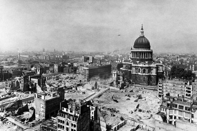
This free resource is home to an extensive collection of documents, images, maps, books and films covering around 900 years of London’s history. Took the opportunity to apply for a History card and also look around the current (to 27 April 2016) exhibition on War in London. This includes some very sobering photographic archives showing the destruction caused by the bombing raids of both World Wars. As the image below dramatically reminds, St Pauls only survived WWII against some pretty considerable odds.
At either end of Northampton Road lies Bowling Green Lane which segues into Corporation Row which runs along the back of the former Hugh Myddleton (that man again) School. There were separate entrance gates here for Boys, Girls and so-called Special Girls. This was not intended in the Jose Mourinho sense of the word I believe but probably alludes to the fact that there was a separate school of deaf and dumb children on the premises at one time.

Turning right back into Woodbridge Street and again into Sans Walk brings us round to the front side of the building, now offices and flats (of course).


Head down St James Walk next and cut through St James’s Church Gardens to reach the two limbs of Clerkenwell Close on the eastern side of which sits the Peabody Estate, Pear Tree Court. This was one of six such estates built by the Peabody Trust in the late 1870s and 80s on sites cleared by the Metropolitan Board of Works. The Peabody Trust was one of the original London Housing Associations established in 1862 by the American Banker, George Peabody. It continues to fulfil that charitable mission to the present day.

Also on Clerkenwell Close are former warehouses which were built in 1895–7 as the central stores of the London School Board. This is one of the several original entrances still visible today.

Pear Tree Court leads out onto Farringdon Lane where we head south alongside the railway and past Vine Street Bridge. The sign in the picture below helpfully provides a number call if your vehicle should crash into the bridge.


Ok so we’re on to the final lap of this one, left into Clerkenwell Road then up Clerkenwell Green and back onto Clerkenwell Close to take a closer look at St James’s Church. This has apparently been a religious site since the 12th century though the current church dates from 1792. Unfortunately it wasn’t possible to get a look at the interior of the church, or its much vaunted crypt, on this occasion.


By way of compensation today’s Pub of the Day, the splendid Three Kings, is just across the road. A public house has occupied this spot since at least the 18th century, when it was originally known as the Three Johns. The somewhat unprepossessing exterior (blame a re-tiling job in 1938) is more than made up for by the splendidly idiosyncratic interior styling.


Until next time…


