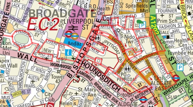
Shifting slightly further to the east for this excursion which starts out where we left off a couple of months back on Aldgate High Street then heads south down to Tower Hill, stopping short of the Tower itself, before snaking west and north through the City. Because this walk took place on Easter Sunday the area was atypically quiet apart from the inevitable tourist throng near the Tower and, less obviously, in the vicinity of the Gherkin.

So we set out on Aldgate High Street opposite Aldgate tube station and proceed south down Little Somerset Street. Looking behind us gives a background glimpse of what’s to come later.

Reaching Mansell Street we continue south turn right along Haydon Street and then when this adjoins onto the Minories head northward to return to Aldgate High Street opposite the church of St Botolph without Aldgate. This is the second time we’ve encountered St Botolph; he was “without Bishopsgate” a few posts back. In fact there were four medieval churches built in London in honour of this particular saint, all of which stood by one of the gates of the London Wall (more of that later). Aldersgate is the other one of those that survives while the church at Billingsgate wasn’t rebuilt after the Great Fire. St Botolph’s was often referred to as the “Church of Prostitutes” in the late Victorian period. To escape arrest by the police the local ladies of the night would parade around the island in a sea of roadways on which the church stands.

Turn south again, this time down Jewry Street which is the site of the Sir John Cass Foundation. John Cass (1661 – 1718) was both a Sheriff and Alderman of the City of London and in 1710 set up a school for 50 boys and 40 girls which originally occupied buildings in the churchyard. After his death, despite his will being incomplete and contested, his wish to leave the majority of his estate to the school was upheld though it took thirty years. So the Foundation came into being in 1748 and in 1899 a Technical Institute was created alongside the school and this moved into the new-build premises on Jewry Street, becoming the Sir John Cass College in 1950.


After nipping briefly into Saracens Head Yard we take the next right turn, Carlisle Avenue, which takes us into Northumberland Alley which meets its end at the wonderfully-named Crutched Friars. Crutched Friars is one of the alternative names of the Roman Catholic order Fratres Cruciferi (Cross-bearing brethren). Crutched refers to the crucifix-surmounted staff which they carried about with them. Next up, turning north again, is Rangoon Street, which is barely more than an alcove, before we switch eastward down India Street. Turn right next down Vine Street (not the one which forms part of the Orange set of properties in Monopoly – that’s over near Piccadilly) then veer off to the left, down Crosswall which takes us into Portsoken Street. This latter skirts one side of a charming small park wedged in amongst some less than charming buildings.

At the end of Portsoken Street we swing round Mansell Street and Goodman’s Yard to loop back onto Minories and then turn south under the railway bridge and past Tower Gateway station, one of the two western termini of the DLR.

So we’re now onto Tower Hill and moving west parallel to the north side of the Tower of London. Here there is one of the most substantial surviving sections of the London Wall built around the city by the Romans in around 200 AD. In total the wall was about 4km long enclosing some 330 acres and including the four city gates (mentioned previously) with a further entrance to the legionary fortress at Cripplegate.


Turn north into Cooper’s Row and head up past Trinity Square Gardens back to Crosswall (whose name now makes perfect sense). Duck through American Square onto the southern section of Vine Street which seems to lead nowhere but then suddenly and bizarrely emerges into a crescent of replica Georgian houses (some rebuilt immediately post WW2 others as part of a 1980s redevelopment) called, simply and literally, Crescent.

Double back and cut through a series of alleyways leading out onto Cooper’s Row again. Cross over and proceed west along Pepys Street before turning south down Savage Gardens. This returns us to Trinity Square, to No. 10 Trinity Square in fact, which links neatly back to the previous post for this is the first permanent HQ of the Port of London Authority. It was built in the Beaux Arts style by John Mowlem & Co to a design of Sir Edwin Cooper and was opened by then Prime Minister, David Lloyd-George, in 1922. The façade of the building is interspersed with Corinthian columns and high above the front entrance is a sculpture of Old Father Thames, holding his trident and pointing east in homage to the trade between nations. In 1946 the General Assembly of the United Nations held its inaugural reception here, in what is now known as the UN ballroom. In the 1970’s the PLA moved out to Tilbury and no. 10 was renovated; becoming the home of insurance broker Willis Faber until 2008. Two years after they left a Chinese Investment company bought the Grade II-listed building and after a six year multi-million pound renovation it was brought back to life as a Four Seasons Hotel. In the interim it had a walk-on part in the James Bond Skyfall film as a location for a meeting between M (Dame Judi Dench) and Gareth Mallory (Ralph Fiennes).
Moving on clockwise round the square we come first to Trinity House which is the home of the organisation that began life as The Corporation of Trinity House (or to give it its full name The Master Wardens and Assistants of the Guild Fraternity or Brotherhood of the Most Glorious and Undivided Trinity and of Saint Clement in the Parish of Deptford Strond in the County of Kent), under Royal Charter of 1514 with a remit to regulate pilotage on the River Thames and provide for aged mariners. Today Trinity House is the UK’s largest maritime charity dedicated to safeguarding shipping and seafarers as well as incorporating the General Lighthouse Authority (GLA) for England & Wales. The GLA is responsible for a range of aids to navigation from lighthouses to radar beacons but, confusingly, is separate from HM Coastguard (which looks after all aspects of search and rescue).
The building itself dates to 1796 and was designed by architect Samuel Wyatt.

On the east of the square at no.43 is a blue plaque commemorating Reverend Philip “Tubby” Clayton (1885 – 1972), founder of the international Christian movement Toc H. And next door at no.41 is a memorial to Viscount Wakefield of Hythe (1859 – 1941) who founded the Castrol lubricants company and was a Lord Mayor of London and also Tubby’s mate.

We now take a stroll through Trinity Square Gardens which is dominated by the Merchant Navy Memorial. The original, post WW1, section was designed by Sir Edwin Lutyens with sculpture by Sir William Reid-Dick and was unveiled by Queen Mary on 12 December 1928. It commemorates almost 12,000 Mercantile Marine casualties who have no grave but the sea, including almost 1,200 lost when the Lusitania was sunk in 1915. The WW2 extension, which commemorates almost 24,000 casualties, was designed by Sir Edward Maufe, with sculpture by Charles Wheeler and was unveiled by Queen Elizabeth II on 5 November 1955.
Leaving the gardens on the west side we find ourselves back outside Ten Trinity Square, which as I mentioned is now a Four Seasons hotel having opened a mere three months back in January 2017. On impulse born of curiosity I decide to head inside for a lunchtime cocktail at the Rotunda bar. I have the place to myself pretty much and the very amiable bartender rustles me up a concoction called (appropriately) a Shivering Timbers which will set me back £15 plus service. Still it’s just about worth it to take in the elaborately refurbished interior (and make a luxurious and desperately need toilet stop). As well as the hotel the building incorporates 41 private residences and a private members’ club. At the time of speaking £440 a night for the cheapest room doesn’t include access to the spa and swimming pool as these won’t be open for a few more weeks.
Leaving the hotel, head west along Muscovy Street and then turn north up Seething Lane before returning eastward along Pepys Street and via another section of Savage Gardens find ourselves back on Crutched Friars. From here we continue north up Lloyds Avenue most of the buildings on which were built under a redevelopment of derelict East India Company warehouses at the turn of the 20th century. Coronation House at no. 4, built in 1904, eventually became absorbed into the Lloyd’s Register building which stood on the corner with Fenchurch Street.

Lloyd’s Register (not to be confused with Lloyds of London) began life in 1760 in a London coffee house as a marine classification society. Nowadays it operates as a global provider of risk assessment and technical consultancy services across numerous industrial sectors but is still wholly owned by the charitable Lloyd’s Register Foundation.
It moved into the premises at 71 Fenchurch Street, designed by Thomas Colcutt, in 1901. Almost 100 years later it moved again – just a few yards further along Fenchurch Street – to a glass, steel and concrete skyscraper designed by the Richard Rogers Partnership (who of course had previously been responsible for the much better known Lloyd’s of London building – of which we shall hear more another time).


We’re going east again now on Fenchurch Street and at the junction with Leadenhall Street where it turns into Aldgate High Street we find the Aldgate Pump. This historic water pump, which has stood on this spot since 1876, marks the start of the A11 road that eventually leads to Norwich. It’s also considered by many to be the symbolic start of the East End. The wolf’s head is supposed to commemorate the last wolf shot in the City of London though there appears to be no record of when that might have been.

Moving on we make a sharp left into Mitre Street and then cut through St James’s Passage to join Dukes Place. Turn the corner and we’re on to Houndsditch. Head up here as far as Creechurch Lane which we follow back across Dukes Place as far as the junction with Heanage Lane which we take back up to Bevis Marks (which Dukes Place merges into and which gets several mentions in Dickens’s Old Curiosity Shop). From here we take the next right, going north, Goring Street to return to Houndsditch. Turn left then left again down the top section of St Mary Axe to revisit Bevis Marks. Turn south this time and then loop round Bury Street past Cunard Place and back onto the lower stretch of Creechurch Lane. Here on the corner with Leadenhall Street stands the actual Cree Church, the Church of St Katharine Cree to be precise. The church was founded in 1280 and the present building dates from around 1630. It is the only remaining Jacobean church in London having survived both the Great Fire and the Blitz practically unscathed.

Crossing over Leadenhall Street we squeeze through the alley known as Fenchurch Buildings and having traversed Fenchurch Street again navigate a couple more alleys in the form of St Katharine’s Row and French Ordinary Court which take us round the back of Fenchurch Street Station and onto Hart Street. Turning west we reach another medieval church that eluded the clutches of the Great Fire, St Olaves. This one dates all the way back to 1450 in its present form (more or less – it wasn’t so lucky in the Blitz and had to be extensively restored after the war). The fabulously macabre entrance to the churchyard was a 1658 addition. The church is dedicated to the patron saint of Norway, King Olaf II and the Norwegian connection continued during and after WW2 when King Haakon VII of Norway worshipped here in exile and then in 1954 presided over the rededication ceremony. Samuel Pepys was buried here in 1703 and it is also, weirdly, recorded as the last resting place of the pantomime character Mother Goose (?). Her internment apparently took place in 1586 according to the parish registers and the event is commemorated by a plaque on the outside of the church.
Leaving St Olaves behind we move northward again next, up New London Street into London Street (both doing less than nothing to deserve such names) and round Fenchurch Place to the front of Fenchurch Street Station, gateway to Essex. The station opened in 1841 initially to serve the London and Blackwall Railway but was reconstructed after just 13 years when the London, Tilbury and Southend Railway began operations. It’s one of the smallest termini in London and uniquely has no interchange with the underground.

Back on Fenchurch Street we continue west for a bit and then proceed north up Billeter Street resurfacing on Leadenhall Street. Keep the westerly trajectory before turning north again up the bottom-most section of St Mary Axe. On the right here is yet another of the City churches that survived the double whammy of the Great Fire and the Blitz. The present St Andrew Undershaft was built in 1532 in the Perpendicular style (a subdivision of Gothic, so-called because of its fondness for vertical lines). The church’s name derived from the shaft of the maypole that was set up opposite the church – though only until 1547 when it was seized by a mob and destroyed as a “pagan idol” (now that’s a show I’d like to see).

Continuing north we arrive at the foot of St Mary Axe’s most famous resident, no. 30 more commonly known as “The Gherkin”. The Gherkin, designed and engineered by Norman Foster and Partners and the Arup Group respectively, was completed in December 2003 and opened in April 2004. 41 storeys and 180 metres tall, it stands on the site of the former Baltic Exchange which was irretrievably damaged by the IRA bomb of 1992. It has a floor area of just over half a million square feet including a restaurant on the 39th floor. In November 2014 the building was bought by the Safra Group, controlled by the Brazilian billionaire Joseph Safra, for £700m (£150m than the price originally anticipated). The sculpted head you can see below is another work in the Sculpture in the City 2016 series; “Laura” by Jaume Plensa.
After a circuit round the base of the Gherkin we meander off to the west again down the dead end that is Undershaft. Doubling back and then turning left down Great St Helens we pass in front of St Helen’s Bishopsgate which, you’ve guessed it, also survived the Great Fire and the Blitz (it’s almost like there was some kind of divine providence at work here). Wasn’t so fortunate when it came to that IRA bomb in 1992 however; that took the roof off and also destroyed one of the City’s largest medieval stained glass windows. The church started out as a priory for Benedictine nuns in the early 13th century and was Shakespeare’s parish church when he lived in the area in the 1590s. The artwork on display outside the church, Shan Hur’s “Broken Pillar #12” has been left in place from the 2015 Sculpture in the City collection.
At the end of Great St Helens we emerge onto Bishopsgate and head north towards Liverpool Street station. Final point of interest on today’s journey stands at no.110 bounded on its other three sides by Camomile Street, Outwich Street and Houndsditch. Completed in 2011 the building was originally known as the Heron Tower after its owners Heron International but in 2014 its primary tenant pressed for the name to be changed to the pitifully naff Salesforce Tower. The City of London eventually ruled that it should officially be called simply 110 Bishopsgate. Whatever its name the building stands 230 metres tall (including the 28 metre mast) with 46 floors. It currently holds the record as the City of London’s tallest structure, having eclipsed Tower 42 when construction reached the 44th floor.
Situated on floors 38 and 39, Sushi Samba restaurant is one of the top restaurant destinations for the young, aspiring (and easily impressed) denizens of the Home Counties and for those without a head for heights, the lobby contains a 70,000 litre aquarium.

And I think that’s us finally done for this time around (and I really expected this one would reverse the trend for longer and longer posts).