
Something of a milestone reached today as, for the first time, we’ve ventured south of the river. First time for this blog that is; Waterloo Station, where today’s journey starts, has been my point of entry to central London for the best part of three decades.
We begin our excursion by heading round the southern end of the station and beyond Lambeth North tube station before cutting down towards the river through Archbishop’s Park. Having circumnavigated St Thomas’ Hospital, partly by way of a stroll along the Albert Embankment, we loop back under the railway arches and then cross over Westminster Bridge. Turning east on the other side, Victoria Embankment takes us along the river to Hungerford Bridge where we cross back over and fight our way along Queen’s Walk through the tourist hordes and past the London Eye and County Hall. After that there’s a full circuit of Waterloo Station and we’re done.
I should also mention that this took place on the day of the England v Croatia semi-final so the (very hot) air was filled with expectation and trepidation – though not in the vicinity of those aforementioned hordes.

So we start off by exiting the station onto Waterloo Road and turning right, then at the crossroads by the Old Vic we turn right again and follow Baylis Road all the way down to Lambeth North tube. At the top of Kennington Road stands the Lincoln Tower, built in 1876 (the centenary of American independence) in the Gothic revival style as a memorial to Abraham Lincoln. The construction cost of the tower was partly met from funds raised in America by Christopher Newman Hall, the pastor of Surrey Chapel, an independent Methodist and Congregational church based on Blackfriars Road, which had acquired the site in the mid 19th century.

We continue south west on Kennington Road as far as Cosser Street which runs alongside the William Blake (public housing) Estate. At the end of Cosser Street we turn right on Hercules Road for just a few yards before continuing north, underneath the rail tracks, on Virgil Street. When Virgil Street ends at Carlisle Lane the entrance to Archbishop’s Park is immediately opposite. This was originally part of the grounds of nearby Lambeth Palace, the official London residence of the Archbishop of Canterbury, but from 1869 onward was set aside as a play area for children and for ball games and in 1900 was turned into a public park. Ownership remains in the hands of the Church Commissioners. Nowadays the park is also home to Zip Now London (allegedly the world’s longest and fastest city centre zip wire). I would guess it doesn’t take much more than 30 seconds to cover the 225m distance which would make the cheapest ticket equivalent to about 67p per second (about 50% more than Ronaldo earns in the same time).


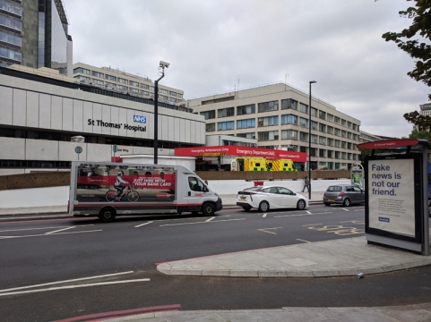
After a circuit of the park, not including a go on the zipline (it wasn’t yet open), we exit onto Lambeth Palace Road opposite the south side of St Thomas’ Hospital, more of which later.
We follow Lambeth Palace Road eastward as it converges towards parallel proximity with the river then drop onto the Albert Embankment and head down river towards Westminster Bridge. This is where you’ll get the best views of the Houses of Parliament (see previous post) and it’s also considerably less busy than, say, the South Bank if you’re after a riverside stroll. Albert Embankment was created by the engineer Sir Joseph Bazalgette for the Metropolitan Board of Works between 1866 and 1869 and included land reclaimed from the river and various small timber and boat-building yards. It was intended to protect low-lying areas of Lambeth from flooding while also providing a new highway to bypass local congested streets. As with its counterpart, the Victoria Embankment, on the north side the street furniture of the Albert Embankment was the creation of George Vulliamy (1817 – 1886). But whereas the sturgeon (or dolphin) lamp posts are common to both sides, the 15 benches on the Albert side have a swan motif in their cast iron arms and panels rather than the sphinxes and camels of the more numerous resting spots on the Victoria side.
The river-facing wing of St Thomas’ Hospital, dates back to 1871 when the hospital moved to this location from Southwark and is now Grade II listed. The hospital, in its original Southwark incarnation, is believed to have been founded towards the end of the 12th century, run by a mixed order of Augustine monks and nuns and dedicated to St Thomas à Becket. When the monastery was dissolved in 1539 during the Reformation the hospital closed but reopened 12 years later when it was rededicated to Thomas the Apostle. In the late 20th century the name was changed from St Thomas’s to St Thomas’ which was undoubtedly due to modern a predilection for simplification but has been justified on the basis that the hospital is associated with two separate men called Thomas. (Though, as the grammar police and I will tell you, this means it should be known as St Thomases’ Hospital).


Once we reach Westminster Bridge and turn right onto Westminster Bridge Road we find ourselves at the main entrance to the modern building, the North Wing, which was completed in 1975. It met with widespread public disaffection at the time, particularly from MPs who felt it ruined their view from the Palace of Westminster. Between the walkway up to the entrance and the embankment a garden area has been created above the car park. At the entrance to this garden stands a memorial to Mary Seacole (1805 – 1881), the British-Jamaican businesswoman and nurse who travelled independently to the Crimea and set up the so-called “British Hotel” behind the battle lines in order to treat wounded servicemen. The statue was unveiled, not without controversy, in 2016. (Inside the hospital buildings is a museum dedicated to Florence Nightingale, that much better known Crimean War “angel of mercy”). Despite the question marks about the efficacy of Mary’s treatments and the claims of her being a medical pioneer she is undoubtedly someone who deserves to be celebrated for what she managed to achieve in the face of twin obstacles of race and gender. The centre of the garden features Naum Gabo’s fountain sculpture Revolving Torsion and just ahead of the main entrance is sculptor Rick Kirby’s work Crossing The Divide from the year 2000. That’s the same year that a statue of Edward VI, originally erected in 1739, was moved to its position directly outside the North Wing. It was Edward VI who granted the hospital a royal charter that facilitated its re-establishment post-Reformation.
Following the perimeter of the hospital we return to Lambeth Palace Road and then take a left up Royal Street. This is dominated by the Canterbury House block of social housing flats, built c.1960, which is remarkable in that from the rear it looks like the epitome of a run-down sixties’ estate and yet the front could be mistaken for a 3-star hotel on the Costa Brava.


Next we weave in and out through the tunnels underneath the railtracks out of Waterloo courtesy of Upper Marsh, Carlisle Lane and Centaur Street before ending up back on Hercules Road.
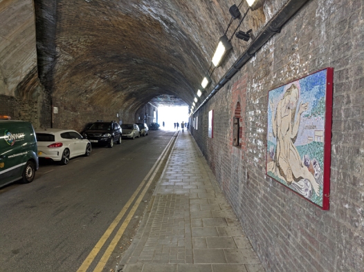
William Blake (1757 – 1827) lived in a building on Hercules Road during the last decade of the 18th century, hence the nearby housing estate named after him and the series of mosaics in the railway tunnels inspired by him. On the way back towards Lambeth North Tube, Newham Terrace offers up one of those historic industrial signage remnants that I’m so fond of.


From the tube station we head back towards the river, starting on Westminster Bridge again and then looping round Addington Street and cutting through (the absurdly named) Forum Magnum Square onto Belvedere Street which runs along the back of the old County Hall.

The main central building of County Hall was built between 1911 and 1922 in an Edwardian Baroque style to the design of architect, Ralph Knott, as the new home of the London County Council (LCC). The LCC was created in 1889 as part of the previous year’s Local Government Act, becoming the first elected authority with responsibility for the whole of London. It’s predecessor, the Metropolitan Board of Works, had government appointed leaders and a more limited set of powers. The north and south blocks of County Hall were added between 1936 and 1939. In 1965 the LCC was superseded by the Greater London Council (GLC) on the back of the 1963 Local Government Act which saw the creation of 32 new boroughs comprising the new metropolis of Greater London, extending into areas such as Croydon and West Ham that were formerly part of Surrey and Essex respectively. It also signalled the effective demise of Middlesex as a separate administrative area. The GLC ran London for 21 years until in 1986, under the aegis of Ken Livingstone, its Labour controlled administration became in embroiled in a death-match with the Conservative government and Margaret Thatcher duly abolished it. Parts of County Hall still remain empty to this day but in now houses two hotels (at opposite ends of the spectrum), a Marriott and a Premier Inn and a number of Merlin Entertainments attractions, which we’ll deal with later.
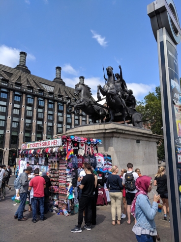
Next we finally cross over the river via the packed to the seams Westminster Bridge. At the north end of the bridge stands the statue to Queen Boudicca and her daughters created by Victorian sculptor, Thomas Thornycroft (1815 – 1885). The statue was commissioned in the 1850’s by Prince Albert and was originally intended to sit atop the central arch of the entrance to Hyde Park. Albert died in 1861 before it was completed and the project then ran into all-too familiar funding issues. Thornycroft managed to complete a full-size model of the work before his own death in 1885 but it wasn’t until 1902 that it was installed here by Westminster Pier thanks to the efforts of his son and the support of the LCC. Which makes it all the more shameful that it’s plinth is currently obscured by a stall hawking tourist tat.
Moving swiftly on we proceed eastward along the Victoria Embankment passing, firstly, the Battle of Britain Memorial unveiled in 2005 to coincide with the 65th anniversary and then the Royal Air Force Memorial of 1923 with its Golden Eagle sculpted by William Reid Dick. In the background beyond the memorial you can see the PS Tattershall Castle, a floating pub that served as a passenger ferry across the Humber Estuary from 1934 to 1973.
We cross back over the river using the western element of the two new footbridges built alongside the Hungerford Railway Bridge in 2002. Officially these are called the Golden Jubilee Bridges in honour of QEII’s fiftieth anniversary on the throne but in reality everyone still refers to them, collectively, as the Hungerford Footbridge. Which is surprising in a way since the original Hungerford Footbridge (on the east side) was notorious for being both unsightly and dangerous and was the scene of horrific murder in 1999 (just a couple of years after the decision to knock down the bridge had already been taken). The railway bridge dates back to 1864 and was designed by Sir John Hawkshaw. It replaced a suspension footbridge of 1845 created by Isambard Kingdom Brunel (the original brick buttresses of which are still in use). The name derives from Hungerford Market, a produce market on the north bank which existed on the site of what is now Charing Cross Station from the late 17th century until, er, they knocked it down to build the station.

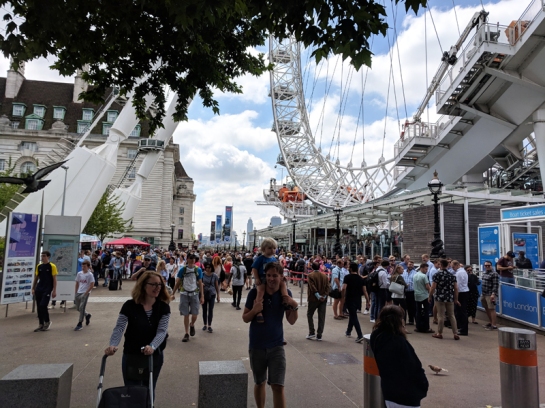
On the other side of the bridge we descend the steps down to Queen’s Walk and head back west towards County Hall. En route we pass the site of the Underbelly Festival which runs throughout the summer months beside Jubilee Gardens featuring comedy, circus and cabaret performances in its Spiegeltent and providing al-fresco drinking and dining.


And so we reach the London Eye which is now apparently the most popular paid tourist attraction in the UK with 3.75 million visitors annually. Quite when it took over the top spot from Madame Tussauds I’m not sure but, ironically, the Tussauds Group were one of the original owners along with British Airways and Marks Barfield (the architects who created it) when it opened in 2000 as part of the Millennium celebrations. At the time it was the tallest Ferris wheel in the world at 135m though that record is now held by the High Roller in Las Vegas at 167.6m. It has also lost out on being the highest public viewing point in London since the Shard was built. It is now owned by Merlin Entertainments who took over Tussauds Group in 2007. BA ended its brand association in 2008 and Coca-Cola became sponsors from the start of 2015.
Merlin Entertainments run a number of other attractions that are based inside the County Hall building: The London Dungeon (relocated here from its original home near London Bridge); Shrek’s Adventure and Sea Life. On a more edifying note I’ll just make mention here of some of the sculptures that adorn the exterior of County Hall. (I should also belatedly namecheck the Ornamental Passions blog which has been an invaluable source of information on this topic). The sculptures on the Jubilee Gardens façade are the work of Alfred Hardiman and are intended to represent Open Spaces and Child Education. Those on the riverside façade are by Ernest Cole (1890 – 1979), who was only 24 when awarded the commission and whose work on the figures was interrupted by First World War in which he was co-opted into the Intelligence Corps. Cole was also responsible for the works on the Westminster Bridge Road side including World Beyond which shows the world resting on the shoulders of three grotesque representatives of the human race with two more contorted figures standing astride it. Not surprisingly, Cole’s work caused something of an uproar when it was unveiled and this led to him being replaced by Hardiman for the later commissions. At the outbreak of WWII, Cole and his wife, Laurie Manly, were briefly imprisoned on suspicion of being fascist sympathisers on account of their subscription to Il Popolo d’Italia the newspaper founded by Mussolini.
I strongly suspect that Cole and Hardiman’s efforts go completely unnoticed by the crowds thronging round the London Eye and along the rest of Queen’s Walk. Having battled through them twice I make my escape, heading up the side of Jubilee Gardens and down Chicheley Street into York Road. Here I head back to the front entrance to Waterloo Station. The station first opened in 1848 so it’s celebrating its 170th anniversary this year. That original station was built by the London and South Western Railway but wasn’t intended to be a terminus, just a stopping point on the way to the City of London. That further extension never materialised however and by the turn of the 20th century the railway company had accepted the fact and recognized that Waterloo needed to be completely rebuilt to function as a proper terminus for the increasing volume of train traffic from the south west. The rebuilt station was formally opened on 21 March 1922 by Queen Mary. The main pedestrian entrance, the Victory Arch (known as Exit 5), was designed by James Robb Scott and is a memorial to company staff who were killed during WWI. It is flanked by two sculptures featuring Roman goddesses; “1914” with Bellona in armour with a sword and torch, and “1918” showing Pax, the goddess of Peace sitting on Earth. Waterloo is now the busiest railway station in the UK, the largest in terms of floor space and with the greatest number of platforms.

Just across from the main entrance, on Mepham Street, is the Hole In The Wall Pub which I visited several times in the late seventies and early eighties. I still recall the horror of using the toilet facilities there so I was more than a little amused to see this recent addition to the local street furniture.


Mepham Street leads out onto Waterloo Road from where we circle past the station for a second time and on this occasion fork right up Spur Road onto Station Approach Road / Cab Road which the taxis use to add an extra few hundred metres to their journeys (just kidding guys). A left turn takes us down to Leake Street which is basically a foot tunnel under the railway. It’s home to The Vaults an immersive theatre and alternative arts venue that occupies a maze of previously disused arches underneath Waterloo Station. From late January to late March for the last few years the Vault Festival has been held here; and with over 350 shows across 16 venues it’s fast becoming a serious rival to the Edinburgh Fringe for showcasing new and experimental comedy and theatre.


The Leake Street tunnel is also an officially sanctioned open canvas for graffiti art. Not sure what the protocol is for how long each work is allowed to stay up before being over-sprayed but I suspect this one has already gone (unfortunately).

We retrace our steps up Leake Street and leave via an alternative exit onto Lower Marsh. This always used to be one of my favourite streets in London with a number of idiosyncratic shops selling vintage clothes, jazz books and records, pre-1970’s memorabilia and cut-price designer menswear. Latterly it’s sadly succumbed to the twin curses of redevelopment and rate hikes so almost all of those independent retailers have now gone (apart from the fetish gear suppliers). The shops have of course mostly been replaced by coffee-shops, a couple of which, to their credit, have a decent sense of style. Not quite a pub of the day but I’ll give a shout out to the Scooter Bar where I had a Mexican lager I’ve never heard of before and they let me bring in a take-out of Pad Thai Noodles from one of the several food stalls out on the street.
Ok so we just finish things off with the streets running off Lower Marsh to the south namely Grindal Street, Frazier Street, Murphy Street, Joanna Street and Tanswell Street and then return to the station. For once my timing has clicked as the Band of The Royal Coldstream Guards are belting out a few popular tunes on the concourse and just as I decide to hang around for one more they launch into, what else but, Three Lions. Naturally this brings the house down though unfortunately there is no self-fulfilling prophecy here. Nonetheless these boys in red done good as did the ones over in Russia. Bring on Euro 2020 !


