Day 62 – Tower Bridge – Queen’s Walk – Hay’s Wharf

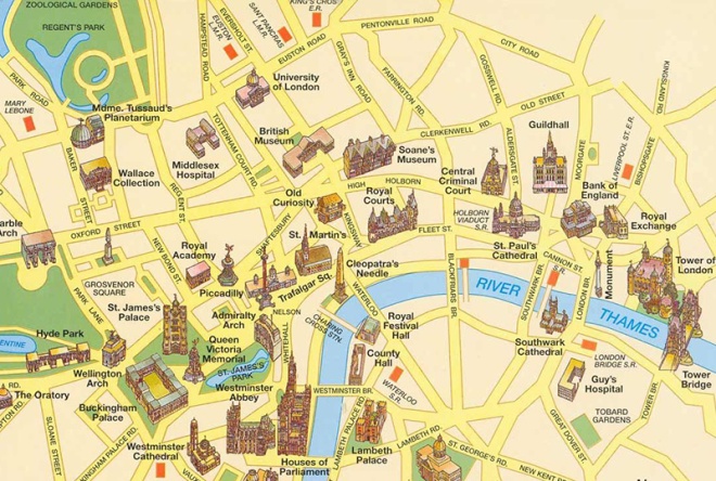
Well it’s taken nearly four years, which is about three and a half more than originally planned, but after 62 days and god knows how many miles every street covered by the central section of the London A-Z has finally been walked. Of course, give it a few more years and no-one will have a clue what that means as they’ll only ever have used Google maps to get around but, just as a reminder, this is roughly the area we’re talking about :
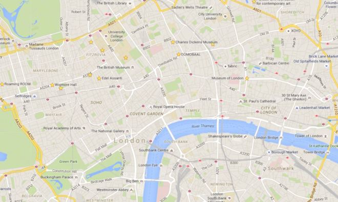
Covered so far May 2016

or to put it another way :

london_tourist_map

And (having just counted them up) that’s roughly 2,028 streets, roads, lanes, walks, passages, avenues, mews(es) and rents altogether. Though I probably shouldn’t count Downing Street as it wasn’t actually possible to set foot there.

Anyway back to today’s valedictory lap which is mercifully short – just across Tower Bridge and west along the river to London Bridge.

Day 63 Route

Tower Bridge was built between 1886 and 1894 and is a combined bascule (the bit that raises and lowers – from the French for “see-saw”) and suspension bridge. It has a total length of 244m and the two towers are 65m high. Over 50 designs had been submitted for the new river crossing and the successful proposal for a bascule bridge was a collaboration between Horace Jones, the City Architect, and engineer, John Wolfe Barry. The incorporation of twin towers with connecting walkways was intended to allow pedestrians to be able to continue to cross the river when the bridge was raised. However, in 1910 the walkways were closed due to lack of use – the general public preferred to wait for the bascules to close rather than clamber up the two hundred-odd stairs and (allegedly) run a gauntlet of pickpockets and prostitutes once they got to the top. Only in 1982 with the creation of the Tower Bridge exhibition were the Walkways re-opened and covered over. Two massive piers were sunk into the river bed to support the construction and over 11,000 tons of steel provided the framework for the Towers and Walkways. This framework was clad in Cornish granite and Portland stone to protect the underlying steelwork and to give the Bridge a more pleasing appearance.

This slideshow requires JavaScript.

Compared to many London attractions entry to the Tower Bridge exhibition is relatively reasonably priced at just under a tenner. This gets you up to the walkways, 42m above the river, and also includes access to the engine rooms. I chose to climb up the 200-plus steps inside the north tower rather than take the lift. Those that go for the latter option miss out on half the exhibition (including the “dad-dancing diver – you’ll see what I mean). Each walkway now includes a short glass-floored section which is not great for those that lack a head for heights. If these had only been configured “à la bascule” then the world would be able to rid itself of a bevy of annoying teenagers on regular basis.

This slideshow requires JavaScript.

To get to the Engine Rooms, which are situated underneath the southern end of the bridge, you follow a blue line from the base of the south tower. The bascules are operated by hydraulics, originally using steam to power the enormous pumping engines. The energy created was stored in six massive accumulators so that, as soon as power was required to lift the bridge, it was always readily available. The accumulators fed the driving engines, which drove the bascules up and down. Despite the complexity of the system, the bascules only took about a minute to raise to their maximum angle of 86 degrees. Today, the bascules are still operated by hydraulic power, but since 1976 they have been driven by oil and electricity rather than steam. The original pumping engines, accumulators and boilers are now exhibits within the Engine Rooms.

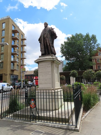
We descend from the west side Tower Bridge Road down onto Queen’s Walk and then turn left immediately and follow Duchess Walk past a line of upscale eateries to Queen Elizabeth Street. On the triangular island bordered by this, Tooley Street and TBR stands a statue of Samuel Bourne Bevington (1832 – 1907) who was Bermondsey’s first mayor and came from a Quaker family who made their fortune in the local leather trade.  The sculptor was Sydney March (1876 – 1968) who was something of a go-to guy at the start of the 20th century if you wanted a monument to a major figure of Empire or a WW1 memorial. Beyond this statue (and you can only just see the plinth in the photo below) is a bust of the far more significant figure of Ernest Bevin (1881 – 1951) who was co-founder of the Transport and General Workers’ Union and served as Foreign Secretary in the 1945-51 Labour Government.
IMG_1033

At the junction of Queen Elizabeth Street and Tooley Street sits the building that was built in 1893 as a new permanent home for St Olaves’ Grammar School. The school was founded in the late 16th century following a legacy of £8 a year granted in the will of Southwark brewer, Henry Leeke. The building on QE Street was designed by Edward William Mountford, the architect of the Old Bailey. The school upped and decamped to suburban Orpington in 1968 and the building was acquired for use as an annexe by South London College. That tenure lasted until 2004 after which the listed building lay idle for ten years until it was bought by the Lalit Group as the latest addition to their chain of luxury boutique hotels, opening in 2017.

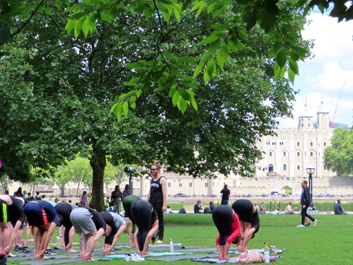
We turn right past the west side of the hotel down Potters Fields which runs into its eponymous park where a lunchtime session of Bikram yoga is in full swing.
IMG_1039

On the north side of the park, heading back towards Tower Bridge is London’s newest major theatre, the Bridge, founded by former National Theatre luminaries, Nicholas Hytner and Nick Starr, and opened in 2017.  Diagonally opposite across the park stands City Hall the headquarters of the Greater London Authority (GLA) a combination of the Mayor of London’s office and the London Assembly. The building was designed by Norman Foster and opened for business in 2002, two years after the creation of the GLA. The unusual shape of the building was supposedly intended to minimise surface area and thus improve energy efficiency but the exclusive use of glass for the exterior has more than offset any benefit this confers. In a singular display of unity, former Mayors, Ken Livingstone and Boris Johnson, have both likened the form of the building to a particular element of the male anatomy; the former dubbing it “the Glass Testicle” and the latter “the Glass Gonad”.

City Hall forms part of a larger riverside development, called More London, with the usual mix of offices, shops and restaurants, which covers the area once filled with wharves and warehouses forming part of the so-called Upper Pool of London. Adjacent to City Hall is a sunken amphitheatre called The Scoop which hosts open-air music performances and film screenings during the summer months (and more lunchtime yoga as you can see below).
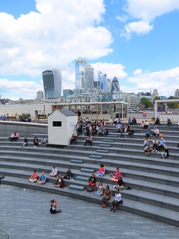
IMG_1046

In order to arrive at The Scoop we cross Potters Fields Park back to Tooley Street and return via Weaver’s Lane and More London Riverside. En route we pass through a herbaceous garden, of forty different perennial species, designed by the man responsible for the highline garden in New York, Piet Oudolf.

The thoroughfare known as More London Riverside continues beyond The Scoop, veering away from the river in between new HQ’s for accountancy firms Ernst & Young and PWC and lawyers, Norton Rose.
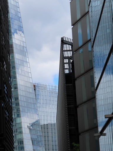
IMG_1048

On arriving at More London Place we head back down to river along Morgan’s Lane, which joins Queen’s Walk by the mooring of HMS Belfast. Although I have been aboard HMS Belfast before that was about 45 years ago I reckon so I was sorely tempted to repeat the experience but time was against me so I spurned the opportunity.

Built by Messrs Harland & Wolff in 1936, HMS Belfast was launched by Anne Chamberlain, wife of the then Prime Minister Neville Chamberlain, on St Patrick’s Day in 1938. A year later she was commissioned into the Royal Navy under the command of Captain G A Scott (the ship that is, not Mrs Chamberlain). The Belfast was immediately called into service patrolling northern waters in an effort to impose a maritime blockade on Germany. However, disaster struck after only two months at sea when she hit a magnetic mine. There were few casualties but the damage to her hull was so severe she was out of action for three years. On rejoining the fleet in 1942 the Belfast played a key role in protecting arctic convoys en route to the USSR. She then went on to spend five weeks supporting the 1944 D-Day landings. She retired from service in 1963 and a few years later a trust was formed under the auspices of the Imperial War Museum to preserve her. After a successful campaign HMS Belfast was opened to the public in 1971, the last remaining vessel of her type – one of the largest and most powerful light cruisers ever built.

Bang in front of HMS Belfast on the riverfront, and taking up valuable real estate that could be otherwise utilised for even more bars and restaurants, is the enduring loveliness that is Southwark Crown Court. Opened in 1983 its 15 courtrooms make it the fourth largest centre for criminal sentencing in the country. It specialises in serious fraud cases. High profile cases in 2019 include the founder of Extinction Rebellion and another activist being cleared of all charges relating to protests in which they entered Kings College London and spray painted “Divest from oil and gas” on the walls and Julian Assange being convicted for breaching bail conditions by taking refuge in the Ecuadorean embassy. (Who says judges are out of touch ?).
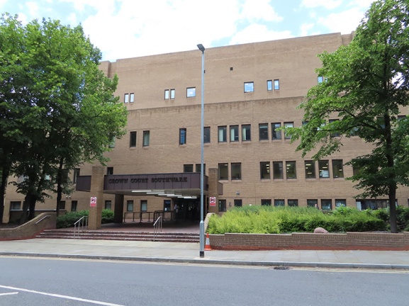
IMG_1051

The front entrance to the court building is away from the river on English Grounds which is off Battle Bridge Lane. Surrounded by the latter, Counter Street and Hay’s Lane is Hay’s Galleria. In 1651 merchant, Alexander Hay took over the lease of a brewhouse beside London Bridge which included a small wharf. By 1710 his family company owned most of the warehouses along the river between London Bridge and the future southern end of Tower Bridge and the expanded wharf officially became known as Hay’s Wharf. By 1838 the company had fallen under the control of John Humphrey Jnr, an Alderman of the City of London. He commissioned architect William Cubitt to design and build a new wharf with an enclosed dock which work was completed in 1857. Unfortunately, just four years later, the Great Fire of Southwark destroyed the warehouses surrounding the new wharf. The buildings that form Hay’s Galleria are some of those arose from the ashes of that fire. Within a few years Hay’s Wharf was handling nearly 80% of the dry produce coming into the capital earning it the soubriquet of “London’s Larder”. The area suffered terrible bombing during WW2 but the Hay’s Wharf company recovered and by 1960, was handling 2m tons of foodstuffs and had 11 cold and cool air stores. However, over the course of the following decade, the explosion in the use of container ships led to the shipping industry moving out to the deep water ports of Tilbury and Felixstowe. Quite rapidly the London docks began to close and in 1969 The Hay’s Wharf Company ceased operations. In the 1980’s the site was acquired for redevelopment by St Martin’s Property Corporation, the real estate arm of the State of Kuwait’s sovereign wealth fund. Hay’s Wharf, renamed Hay’s Galleria, was filled in and paved over and a glass barrel vault installed to join the two warehouse buildings at roof level to create an atrium like area with shops and stalls on ground level with offices in the upper levels. The adjoining wharf to the east, Wilson’s Wharf, was levelled to make way for the Crown Courts and the wharf buildings to the west, Chamberlain’s Wharf together with St Olaf House, were taken over by London Bridge Hospital (see below).

On leaving Hay’s Galleria we continue west along the river as far as London Bridge, passing the aforementioned eponymous hospital. On ascending up to bridge level we turn south and take the walkway that curves round to London Bridge Station then take the stairway down from Duke Street Hill to Tooley Street emerging opposite another part of London Bridge Hospital, a private hospital opened in 1986. St Olaf House, which houses the hospital’s Consulting rooms and Cardiology Department, was built as the Headquarters for Hay’s Wharf in 1931. This outstanding example of an Art Deco building was designed by the famous architect, H.S. Goodhart-Rendel, and is one of his best known works. It is a listed building, with its well-known river facade and its Doulton faience panels by Frank Dobson, showing dock life and the unloading of goods – ‘Capital, Labour and Commerce’.
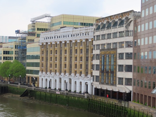
IMG_0915

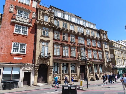
The building on Tooley Street is somewhat less impressive and so perhaps not the most fitting way to close this project. But then again this has not just been about venerable and grandiose old buildings and the ports of call for the open-top bus tours. It’s been about poking into every corner of the heart of this great city and circulating round each and every one of its arteries from the grandest boulevard to the grimiest cul-de-sac. In that spirit therefore, please salute these former shipping offices which first saw the light of day in 1860.
IMG_1055

And so it’s goodbye from me…..for now.


Day 40 – Aldgate – Tower Hill – Fenchurch Street

Shifting slightly further to the east for this excursion which starts out where we left off a couple of months back on Aldgate High Street then heads south down to Tower Hill, stopping short of the Tower itself, before snaking west and north through the City. Because this walk took place on Easter Sunday the area was atypically quiet apart from the inevitable tourist throng near the Tower and, less obviously, in the vicinity of the Gherkin.

Day 40 Route

So we set out on Aldgate High Street  opposite Aldgate tube station and proceed south down Little Somerset Street. Looking behind us gives a background glimpse of what’s to come later.

IMG_20170416_112536

Reaching Mansell Street we continue south turn right along Haydon Street and then when this adjoins onto the Minories head northward to return to Aldgate High Street opposite the church of St Botolph without Aldgate. This is the second time we’ve encountered St Botolph; he was “without Bishopsgate” a few posts back. In fact there were four medieval churches built in London in honour of this particular saint, all of which stood by one of the gates of the London Wall (more of that later). Aldersgate is the other one of those that survives while the church at Billingsgate wasn’t rebuilt after the Great Fire. St Botolph’s was often referred to as the “Church of Prostitutes” in the late Victorian period. To escape arrest by the police the local ladies of the night would parade around the island in a sea of roadways on which the church stands.

IMG_20170416_113557

Turn south again, this time down Jewry Street which is the site of the Sir John Cass Foundation. John Cass (1661 – 1718) was both a Sheriff and Alderman of the City of London and in 1710 set up a school for 50 boys and 40 girls which originally occupied buildings in the churchyard.  After his death, despite his will being incomplete and contested, his wish to leave the majority of his estate to the school was upheld though it took thirty years. So the Foundation came into being in 1748 and in 1899 a Technical Institute was created alongside the school and this moved into the new-build premises on Jewry Street, becoming the Sir John Cass College in 1950.

After nipping briefly into Saracens Head Yard we take the next right turn, Carlisle Avenue, which takes us into Northumberland Alley which meets its end at the wonderfully-named Crutched Friars. Crutched Friars is one of the alternative names of the Roman Catholic order Fratres Cruciferi (Cross-bearing brethren). Crutched refers to the crucifix-surmounted staff which they carried about with them. Next up, turning north again, is Rangoon Street, which is barely more than an alcove, before we switch eastward down India Street. Turn right next down Vine Street (not the one which forms part of the Orange set of properties in Monopoly – that’s over near Piccadilly) then veer off to the left, down Crosswall which takes us into Portsoken Street. This latter skirts one side of a charming small park wedged in amongst some less than charming buildings.

IMG_20170416_114946

At the end of Portsoken Street we swing round Mansell Street and Goodman’s Yard to loop back onto Minories and then turn south under the railway bridge and past Tower Gateway station, one of the two western termini of the DLR.

IMG_20170416_115538

So we’re now onto Tower Hill and moving west parallel to the north side of the Tower of London. Here there is one of the most substantial surviving sections of the London Wall built around the city  by the Romans in around 200 AD. In total the wall was about 4km long enclosing some 330 acres and including the four city gates (mentioned previously) with a further entrance to the legionary fortress at Cripplegate.

Turn north into Cooper’s Row and head up past Trinity Square Gardens back to Crosswall (whose name now makes perfect sense). Duck through American Square onto the southern section of Vine Street which seems to lead nowhere but then suddenly and bizarrely emerges into a crescent of replica Georgian houses (some rebuilt immediately post WW2 others as part of a 1980s redevelopment) called, simply and literally, Crescent.

IMG_20170416_120510

Double back and cut through a series of alleyways leading out onto Cooper’s Row again. Cross over and proceed west along Pepys Street before turning south down Savage Gardens. This returns us to Trinity Square, to No. 10 Trinity Square in fact, which links neatly back to the previous post for this is the first permanent HQ of the Port of London Authority. It was built in the Beaux Arts style by John Mowlem & Co to a design of Sir Edwin Cooper and was opened by then Prime Minister, David Lloyd-George, in 1922. The façade of the building is interspersed with Corinthian columns and high above the front entrance is a sculpture of Old Father Thames, holding his trident and pointing east in homage to the trade between nations. In 1946 the General Assembly of the United Nations held its inaugural reception here, in what is now known as the UN ballroom. In the 1970’s the PLA moved out to Tilbury and no. 10 was renovated; becoming the home of insurance broker Willis Faber until 2008. Two years after they left a Chinese Investment company bought the Grade II-listed building and after a six year multi-million pound renovation it was brought back to life as a Four Seasons Hotel. In the interim it had a walk-on part in the James Bond Skyfall film as a location for a meeting between M (Dame Judi Dench) and Gareth Mallory (Ralph Fiennes).

This slideshow requires JavaScript.

Moving on clockwise round the square we come first to Trinity House which is the home of the organisation that began life as The Corporation of Trinity House (or to give it its full name The Master Wardens and Assistants of the Guild Fraternity or Brotherhood of the Most Glorious and Undivided Trinity and of Saint Clement in the Parish of Deptford Strond in the County of Kent), under Royal Charter of 1514 with a remit to regulate pilotage on the River Thames and provide for aged mariners. Today Trinity House is the UK’s largest maritime charity dedicated to safeguarding shipping and seafarers as well as incorporating the General Lighthouse Authority (GLA) for England & Wales. The GLA is responsible for a range of aids to navigation from lighthouses to radar beacons but, confusingly, is separate from HM Coastguard (which looks after all aspects of search and rescue).

The building itself dates to 1796 and was designed by architect Samuel Wyatt.

IMG_20170416_121211

On the east of the square at no.43 is a blue plaque commemorating Reverend Philip “Tubby” Clayton (1885 – 1972), founder of the international Christian movement Toc H. And next door at no.41 is a memorial to Viscount Wakefield of Hythe (1859 – 1941) who founded the Castrol lubricants company and was a Lord Mayor of London and also Tubby’s mate.

IMG_20170416_121349

We now take a stroll through Trinity Square Gardens which is dominated by the Merchant Navy Memorial. The original, post WW1, section was designed by Sir Edwin Lutyens with sculpture by Sir William Reid-Dick and was unveiled by Queen Mary on 12 December 1928.  It commemorates almost 12,000 Mercantile Marine casualties who have no grave but the sea, including almost 1,200 lost when the Lusitania was sunk in 1915. The WW2 extension, which commemorates almost 24,000 casualties, was designed by Sir Edward Maufe, with sculpture by Charles Wheeler and was unveiled by Queen Elizabeth II on 5 November 1955.

This slideshow requires JavaScript.

Leaving the gardens on the west side we find ourselves back outside Ten Trinity Square, which as I mentioned is now a Four Seasons hotel having opened a mere three months back in January 2017. On impulse born of curiosity I decide to head inside for a lunchtime cocktail at the Rotunda bar. I have the place to myself pretty much and the very amiable bartender rustles me up a concoction called (appropriately) a Shivering Timbers which will set me back £15 plus service. Still it’s just about worth it to take in the elaborately refurbished interior (and make a luxurious and desperately need toilet stop). As well as the hotel the building incorporates 41 private residences and a private members’ club. At the time of speaking £440 a night for the cheapest room doesn’t include access to the spa and swimming pool as these won’t be open for a few more weeks.

This slideshow requires JavaScript.

Leaving the hotel, head west along Muscovy Street and then turn north up Seething Lane before returning eastward along Pepys Street and via another section of Savage Gardens find ourselves back on Crutched Friars. From here we continue north up Lloyds Avenue most of the buildings on which were built under a redevelopment of derelict East India Company warehouses at the turn of the 20th century. Coronation House at no. 4, built in 1904,  eventually became absorbed into the Lloyd’s Register building which stood on the corner with Fenchurch Street.

IMG_20170416_131130

Lloyd’s Register (not to be confused with Lloyds of London) began life in 1760 in a London coffee house as a marine classification society. Nowadays it operates as a global provider of risk assessment and technical consultancy services across numerous industrial sectors but is still wholly owned by the charitable Lloyd’s Register Foundation.

It moved into the premises at 71 Fenchurch Street, designed by Thomas Colcutt, in 1901. Almost 100 years later it moved again – just a few yards further along Fenchurch Street – to a glass, steel and concrete skyscraper designed by the Richard Rogers Partnership (who of course had previously been responsible for the much better known Lloyd’s of London building – of which we shall hear more another time).

We’re going east again now on Fenchurch Street and at the junction with Leadenhall Street where it turns into Aldgate High Street we find the Aldgate Pump. This historic water pump, which has stood on this spot since 1876, marks the start of the A11 road that eventually leads to Norwich. It’s also considered by many to be the symbolic start of the East End. The wolf’s head is supposed to commemorate the last wolf shot in the City of London though there appears to be no record of when that might have been.

IMG_20170416_131442

Moving on we make a sharp left into Mitre Street and then cut through St James’s Passage to join Dukes Place. Turn the corner and we’re on to Houndsditch. Head up here as far as Creechurch Lane which we follow back across Dukes Place as far as the junction with Heanage Lane which we take back up to Bevis Marks (which Dukes Place merges into and which gets several mentions in Dickens’s Old Curiosity Shop). From here we take the next right, going north, Goring Street to return to Houndsditch. Turn left then left again down the top section of St Mary Axe to revisit Bevis Marks. Turn south this time and then loop round Bury Street past Cunard Place and back onto the lower stretch of Creechurch Lane. Here on the corner with Leadenhall Street stands the actual Cree Church, the Church of St Katharine Cree to be precise. The church was founded in 1280 and the present building dates from around 1630. It is the only remaining Jacobean church in London having survived both the Great Fire and the Blitz practically unscathed.

IMG_20170416_133106

Crossing over Leadenhall Street we squeeze through the alley known as Fenchurch Buildings and having traversed Fenchurch Street again navigate a couple more alleys in the form of St Katharine’s Row and French Ordinary Court which take us round the back of Fenchurch Street Station and onto Hart Street. Turning west we reach another medieval church that eluded the clutches of the Great Fire, St Olaves. This one dates all the way back to 1450 in its present form (more or less – it wasn’t so lucky in the Blitz and had to be extensively restored after the war). The fabulously macabre entrance to the churchyard was a 1658 addition. The church is dedicated to the patron saint of Norway, King Olaf II and the Norwegian connection continued during and after WW2 when King Haakon VII of Norway worshipped here in exile and then in 1954 presided over the rededication ceremony. Samuel Pepys was buried here in 1703 and it is also, weirdly, recorded as the last resting place of the pantomime character Mother Goose (?). Her internment apparently took place in 1586 according to the parish registers and the event is commemorated by a plaque on the outside of the church.

This slideshow requires JavaScript.

Leaving St Olaves behind we move northward again next, up New London Street into London Street (both doing less than nothing to deserve such names) and round Fenchurch Place to the front of Fenchurch Street Station, gateway to Essex. The station opened in 1841 initially to serve the London and Blackwall Railway but was reconstructed after just 13 years when the London, Tilbury and Southend Railway began operations. It’s one of the smallest termini in London and uniquely has no interchange with the underground.

IMG_20170416_134003

Back on Fenchurch Street we continue west for a bit and then proceed north up Billeter Street resurfacing on Leadenhall Street. Keep the westerly trajectory before turning north again up the bottom-most section of St Mary Axe. On the right here is yet another of the City churches that survived the double whammy of the Great Fire and the Blitz. The present St Andrew Undershaft was built in 1532 in the Perpendicular style (a subdivision of Gothic, so-called because of its fondness for vertical lines). The church’s name derived from the shaft of the maypole that was set up opposite the church – though only until 1547 when it was seized by a mob and destroyed as a “pagan idol” (now that’s a show I’d like to see).

IMG_20170416_134926

Continuing north we arrive at the foot of St Mary Axe’s most famous resident, no. 30 more commonly known as “The Gherkin”.  The Gherkin, designed and engineered by Norman Foster and Partners and the Arup Group respectively, was completed in December 2003 and opened in April 2004. 41 storeys and 180 metres tall, it stands on the site of the former Baltic Exchange which was irretrievably damaged by the IRA bomb of 1992. It has a floor area of just over half a million square feet including a restaurant on the 39th floor. In November 2014 the building was bought by the Safra Group, controlled by the Brazilian billionaire Joseph Safra, for £700m (£150m than the price originally anticipated). The sculpted head you can see below is another work in the Sculpture in the City 2016 series; “Laura” by Jaume Plensa.

This slideshow requires JavaScript.

After a circuit round the base of the Gherkin we meander off to the west again down the dead end that is Undershaft. Doubling back and then turning left down Great St Helens we pass in front of St Helen’s Bishopsgate which, you’ve guessed it, also survived the Great Fire and the Blitz (it’s almost like there was some kind of divine providence at work here). Wasn’t so fortunate when it came to that IRA bomb in 1992 however; that took the roof off and also destroyed one of the City’s largest medieval stained glass windows. The church started out as a priory for Benedictine nuns in the early 13th century and was Shakespeare’s parish church when he lived in the area in the 1590s. The artwork on display outside the church, Shan Hur’s “Broken Pillar #12” has been left in place from the 2015 Sculpture in the City collection.

This slideshow requires JavaScript.

At the end of Great St Helens we emerge onto Bishopsgate and head north towards Liverpool Street station. Final point of interest on today’s journey stands at no.110 bounded on its other three sides by Camomile Street, Outwich Street and Houndsditch. Completed in 2011 the building was originally known as the Heron Tower after its owners Heron International but in 2014 its primary tenant pressed for the name to be changed to the pitifully naff Salesforce Tower. The City of London eventually ruled that it should officially be called simply 110 Bishopsgate. Whatever its name the building stands 230 metres tall (including the 28 metre mast) with 46 floors. It currently holds the record as the City of London’s tallest structure, having eclipsed Tower 42 when construction reached the 44th floor.

Situated on floors 38 and 39, Sushi Samba restaurant is one of the top restaurant destinations for the young, aspiring (and easily impressed) denizens of the Home Counties and for those without a head for heights, the lobby contains a 70,000 litre aquarium.

IMG_20170416_134711

And I think that’s us finally done for this time around (and I really expected this one would reverse the trend for longer and longer posts).


Day 31 (part 2) -Finsbury Square – Golden Lane – Charterhouse Square

Second part of today’s walk is itself split into two. First off we continue west from Liverpool Street Station and make a circuit of Finsbury Square before pausing on the eastern side of the Barbican Centre. Then it’s a return trip through the Beech Street tunnel to get to Golden Lane and its eponymous estate; after which we loop round the extensive site occupied by the Charterhouse and one of the four campuses of Queen Mary University traversing Clerkenwell Road, St John Street and Charterhouse Street to finish in Charterhouse Square.

day-31-route_2

day-31-route_3

Leaving Broadgate Circus we turn right along Eldon Street then turn back north up Finsbury Avenue which leads into Finsbury Avenue Square which contains both table tennis tables and a few pieces of public art including this piece, Rush Hour.

p1050953

Exit the square from the north-east corner into Sun Street first turning left then swiftly right into Crown Place and completing a figure of eight involving those two along with Christopher Street, Earl Street and Wilson Street. Continue south on the latter past the Wilson Street Chapel which is currently besieged by both roadworks and redevelopment of the Flying Horse pub next door. The chapel was built in 1889 which (à propos of nothing) is one of the longest Roman Numeral dates to have yet occurred – MDCCCLXXXIX.


p1050954

At the end of Wilson Street turn right along South Place then right again into Dominion Street facing directly towards the back entrance of City Gate House. This was constructed in the mid 1920’s to the design of Sir Giles Gilbert Scott (1880 – 1960) son of the better known and much more prolific George Gilbert Scott, creator of the Midland Hotel St Pancras (as was recorded many posts ago). Giles’ main claim to fame rests on the design of something on a much smaller scale but that’s one for our next post. City Gate House was originally built as a gentleman’s club but it’s not clear how long it lasted as such. American media giant Bloomberg acquired the building in 1991 though in 2015 they sold it on to developers (leasing it back on a temporary basis).

p1050956

Turn left next along Lackington Street then north up Finsbury Pavement (part of the A501) before turning the corner into Finsbury Square. First building you come to is the Norman Foster designed no.50 which is adjacent to City Gate House and which Bloomberg expanded into in 2000. Two years later they created the Bloomberg Space on the ground floor as a showcase for newly-commissioned contemporary visual art. The exhibitions there are generally worth a visit but the current offering left me distinctly underwhelmed I’m afraid.

p1050957

Continue round the square anti-clockwise passing the front of City Gate House and the drinking fountain that was erected by Tom and Walter Smith as a memorial to their mother Martha who died in 1898. Their father, another Tom, was the man who, in 1847, invented the Christmas Cracker. The business he created on the back of this, Tom Smith & Co., subsequently taken on by his three sons, operated from premises in Finsbury Square up until 1953 (when they moved to Norwich).

p1050959

The north side of the square is dominated by the former Triton Court (now known as the AlphaBeta Building). Triton Court was constructed in 1920, comprising three buildings, Mercury, Jupiter and Neptune Houses, internally arranged around a full height 9 storey central atrium. It underwent a first major refurbishment in 1984 and another, costing £36m, has just been completed following the change of name. On top of the tower stands a statue of the messenger of the Gods; Hermes or Mercury depending on whether you favour the Greeks or the Romans.

This slideshow requires JavaScript.

After completing the circuit of Finsbury Square we head west on Chiswell Street where we pass Longbow House which now houses a branch of Currys PC World. This post-war building incorporates a relief of an archer, referencing back to the days when this area was to archery what St Andrews is to golf. That was before the advent of the musket though and the establishment of the Honourable Artillery Company whose grounds lie just to the north of here (see Day 28).

p1050964

Turn south down Finsbury Street and onto Ropemaker Street then continue west past the Barbican Centre and through the Beech Street tunnel to resume the trail at the southern end of Golden Lane. Take the first left into Brackley Street and when this junctions with Viscount Street head south initially into Bridgewater Street then double back and enter the Golden Lane estate from Fann Street.

The Golden Lane Estate was built in the 1950’s in an area which, as we have seen previously, was effectively razed to the ground by the blitz. A competition for the  design had been launched in 1951 and was won by Geoffrey Powell, a lecturer in architecture at Kingston School of Art. He then formed the partnership of Chamberlain, Powell & Bon with two of his fellow lecturers in order to carry out the project – the three had entered into an agreement that if any one of them won they would share the commission. The first  phase was opened in 1957 and the final block completed five years later. The estate consists of a series of relatively low-level maisonette blocks and the 16-storey centrepiece, Great Arthur House, which was the first residential tower block in London over 50 metres in height. The architectural style takes definite inspiration from the work of Le Corbusier but is softened by the use of primary colours on the facades.

At the time of construction the estate was regarded enthusiastically as a template for integrated social housing and it has indubitably stood test of time better than most of its contemporaries. Unsurprisingly, given the location, slightly over half of the 559 flats have been sold on leasehold since the Thatcher government’s introduction of the right to buy scheme. The attractiveness of taking advantage of such opportunity is enhanced by a level of on-site facilities replicated in scant few other London council estates – including a leisure centre with tennis courts and an indoor pool. Since 1997 the estate buildings have been Grade II listed.

So we exit the estate back out onto Golden Lane itself and continue north before turning west onto Baltic Street East and completing a grid consisting of this, Honduras Street, Timber Street, Domingo Street, Crescent Row, Memel Street, Memel Court, Sycamore Street and Baltic Street West. And the only thing of note to record in this whole area is this doorway of a former school which I can find no information about.

p1050969

Anyway, after all that we find ourselves out on the Goswell Road and then turning the corner into Clerkenwell Road where the mural that we saw back in Day 14 has now been replaced by a giant-sized Jessica Ennis-Hill.

Turn south all the way down St John Street to arrive opposite Smithfield Market then take a left down Charterhouse Street which soon splits in two. Take the left fork which takes us past a couple of pubs of note. First is the Smithfield Tavern which on the website which is still running advertises itself as Smithfields’ only vegetarian and vegan pub. You can see how well that worked from the picture below. Second is the Fox and Anchor which in its current four-storey art-nouveau facaded Grade II-listed incarnation has been around since the tail end of the 19th century (though there has been a pub of some kind here for several centuries).

Continuing on we arrive at Charterhouse Square. On the north side of the square sits the Charterhouse,  a former Carthusian monastery which since Henry VIII’s dissolution of the monasteries in the 16th century the house has served as a private mansion, a boys’ school and an almshouse which it remains to this day. The site was originally set aside in the middle of the 14th century as a burial ground for victims of the Black Death and the monastery was established in 1371 on the unused portion of the land. In 1611, the year of his death, Thomas Sutton (1532 – 1611), businessman, civil servant and philanthropist, founded an almshouse for “80 impoverished gentlemen” and a school for 40 boys. Charterhouse School eventually outgrew its premises and moved to Godalming in Surrey in 1872 selling the site to another school, Merchant Taylor’s, which itself moved on in 1933. Today this part of the site is occupied by one of the four campuses of Queen Mary University London. The almshouse, which remains, is formally known as Sutton’s Hospital in Charterhouse and is a registered charity. For historic reasons the residents are still known as “Brothers”.

p1050974p1050975


The entrance to the University campus is via Rutland Place at the north-east corner of the square. On the east side of this lies Dean Rees House, part of the University now but built in 1894 as the Headmaster’s House and still bearing the motif of the Merchant Taylor’s School.

p1050976

The east side of Charterhouse Square itself is dominated by the Art Deco Florin Court built 1935-37 by Guy Morgan & Partners. When the building was refurbished in 1988 the original roof gardens were reinstated and a basement swimming pool added. Post-refurb and through the nineties it found fame in the guise of Whitehaven Mansions home to the TV version of Agatha Christie’s Poirot.

p1050978

Leaving the square via Carthusian Street (named after those monks of course) we arrive on Aldersgate Street, flanking the west side of the Barbican complex, and the finish of today’s perambulations.