Day 61 – London Bridge – Hanseatic Walk – Tower of London

I guess I should begin this post with an apology for raising false expectations because this won’t in fact be the last of these as predicted in the previous post. By the time I’d spent several hours at the Tower of London discretion became the better part of valour and I decided to leave the planned home stretch across Tower Bridge and back along the river to London Bridge for another time. Today’s excursion is therefore restricted to a short but interest-packed stroll across London Bridge from south to north, along the Hanseatic Walk to Southwark Bridge and then back east beside the river to the Tower of London.

Day 61 Route

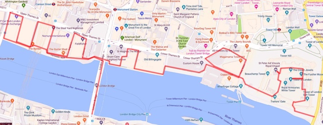
The current, undeniably prosaic, London Bridge is a box girder affair that was completed in 1973, replacing a 19th century stone arch bridge that (as we all know) was dismantled block by block and shipped over Arizona. Though commonly-believed (and repeated by the Yeoman warders at the Tower) the story that the purchaser, Missourian oil millionaire Robert P. McCulloch, thought he was actually buying Tower Bridge is entirely apocryphal. There has been a bridge on this site since Roman times and up until 1729 (when Putney Bridge was constructed) it was the only crossing downstream of Kingston. Several wooden bridges were built and destroyed (either by the elements or enemy forces) during the Anglo-Saxon and Norman periods before Henry II commissioned a new stone bridge on which work began in 1176. It was finally completed 33 years later in the reign of King John. John tried to recoup the cost of building and maintenance by licensing out building plots on the bridge which eventually led to there being around 200 buildings in situ by the time the Tudors came to power. With the buildings came the threat of fire which materialised several times including in 1381 (Peasant’s Revolt), 1450 (Jack Cade’s Rebellion) and 1633 (which was actually fortuitous since it created a natural fire-break at the northern end which halted the spread of the Great Fire three decades later). The southern gatehouse of Henry’s bridge was notoriously used to display the severed heads of deemed traitors such as William Wallace, Jack Cade, Thomas More and Thomas Cromwell. The practice only stopped following the restoration of Charles II. Houses continued to be built on the bridge up until the middle of the 18th century by which time is was finally recognized that the medieval bridge was no longer fit for purpose. It wasn’t until 1831 however that this vision was realised with the opening of the John Rennie designed five stone-arch replacement – and we’ve already revealed the ultimate fate of that one.

IMG_0914
Looking East from London Bridge
IMG_0916
Looking north from London Bridge

At the northern end of London Bridge we drop down onto the riverside to the west and the Hanseatic Walk named after the Hanseatic League, a commercial and defensive confederation of merchant guilds and market towns in Northwestern and Central Europe that dominated maritime trade in the Baltic and North Sea from the 13th to the middle of the 15th century and continued to exist for several centuries after that. The main trading base of the Hanseatic League in London was known as The Steelyard and was situated on the north side of the Thames where one end of the Southwark Railway Bridge now stands. Its remains where uncovered by archaeologists during maintenance work on Cannon Street Station in 1988. In 2005 a Commemorative Plaque was installed at this western end of the Hanseatic Walk by the British- German Association.

Appropriately, Steelyard Passage runs under the rail-line out of Cannon Street and joins the next stretch of the Thames Path that takes us as far as Southwark Bridge. Here we climb up the steps onto Queens Street Place which has a number of richly ornamental facades on its west side. (At this point I should acknowledge again the Ornamental Passions blog which has been an invaluable source of information on architectural sculpture and statuary). First up, on the riverside, is the horrendous neo-neo-classical Vintner’s Place built at the behest of the Vintner’s Company (another of the 12 original Livery Companies). The one saving grace of this building is that it preserved the portico of its predecessor, a 1927 art deco office block called Vintry House. This portico incorporates one of London’s most brazen pieces of sculpture, a full-frontal nude Bacchante (priestess of Bacchus) flanked by a pair of goats and with a cape made from bunches of grapes. The creator of this was one Herbert Palliser and the model was Leopoldine Avico, one of three sisters who posed for numerous sculptors and painters during the early decades of the 20th century.

Next door Thames House was built in 1911 for Liebig’s Extract of Meat Company, which made a Bovril-like goo from boiled up cows at a huge plant in Fray Bentos in Uruguay and later developed the Oxo cube. (Until I looked this up I had no idea there was an actual place called Fray Bentos). The sculptures on the two wings of the façade are the work of Richard Darbe who also dabbled in ivory and ceramic figurines for Royal Doulton.

Finally on the corner with Upper Thames Street is Five Kings House, which was originally the northern end of Thames House but was divided off in 1990. The figures above the entrance were created by George Duncan MacDougald. The male figure appears to represent the god Mercury but it’s not clear who the female figure is meant to be.

IMG_0925

After turning right onto Upper Thames Street we cross between this and the riverfront three times, Bell Wharf Lane, Cousin Lane and All Hallows Lane respectively, to return to the western end of the Hanseatic Walk. As we head back east we pass through Walbrook Wharf which is still an actual operating wharf, acting as a waste transfer station where refuse from central London is loaded onto barges to be shipped downstream to the Belvedere Incinerator which lies halfway between the Woolwich and Dartford crossings. When waste is being transferred onto the barges the riverside walk is closed to pedestrians. This point on the river, known as Dowgate, is also the mouth of the River Walbrook one of London’s lost rivers which now runs completely underground and feeds the sewer system.

There are two more links between Upper Thames Street and the riverside walk before we get back to London Bridge; Angel Lane and Swan Lane. Adjacent to the bridge, still on the west side, is the hall of the Fishmongers’ Company coming in at a mighty 4th place in the Livery Companies’ Order of Precedence which, as we have seen several times before, means that it got its original charter from Edward I (circa 1272). The Company enjoyed a monopoly on the sale of fish in the capital up until the 15th century. The original hall was the first of forty Livery Company halls to be consumed by the Great Fire. However thanks to the Hall’s riverside location, the Company’s most important documents and its iron money chest and silver, were safely transported away by boat. The present hall was the second built after the Great Fire enforced by the start of construction of the “New” London Bridge in 1828. Following substantial destruction during the Blitz the hall underwent major restoration which was completed in 1954. Until 1975 the Company enjoyed the use of a private wharf which excluded the public from access to the riverfront here. The statue in the garden is of “in memory of Mr. James Hulbert late citizen and Fishmonger of London deceased” and was moved here in 1978 having been first erected at St Peter’s Hospital Wandsworth in 1724.

On the east side of the northern end of London Bridge on Lower Thames Street stands the church of St Magnus the Martyr. I’ve visited an awful lot of churches since I started doing this and it’s taken until almost the very end of the mission to discover the two that are probably my favourites, starting with this one. The church was originally established in the early 12th century and it is now accepted that it is dedicated to an earl of Orkney named Magnus who, despite his reputation for piety and gentleness, was killed by one of his cousins in a power struggle around 1116 and was canonised some twenty years later. At various times through the church’s history however it has been contended that the dedication is actually in favour of the St Magnus who was persecuted by the Emperor Aurelian back in the 3rd century AD. The medieval church survived pretty much intact until it was one of the first buildings to be destroyed in the Great Fire, being mere yards from Pudding Lane. Rebuilding after the fire took place (naturally) under the direction of Christopher Wren and was completed in 1676. This new church emerged relatively unscathed from WW2 and what repair work was needed was concluded by 1951, the year after it was designated a Grade I listed building. Though not large, the interior of the church contains a number of interesting artefacts and decorations not least of which is a splendid scale model of Old London Bridge created by David T. Aggett  a liveryman of the Worshipful Company of Plumbers. It also has an historic late 18th century fire engine (well more of a cart really) acquired by the parish in compliance with the Mischiefs by Fire Act of 1708 and the Fires Prevention (Metropolis) Act of 1774. Despite the church’s C of E denomination its interior is very ornate thanks to a neo-baroque style restoration of 1924 which reflected the Anglo-Catholic nature of the congregation at the time. That heritage may also explain why the rector uses the title “Cardinal Rector”, making him the last remaining cleric in the Church of England to use the title Cardinal.

This slideshow requires JavaScript.

On leaving the church we return to the Thames Path and head further east past the riverside facades of Old Billingsgate and Custom House both of which we looked at back in Day 45. The two buildings are separated by Old Billingsgate Walk and beyond the latter Water Lane takes you back up onto Lower Thames Street.

IMG_0931
Old Billingsgate facing the Thames

Looping round Petty Wales and Gloucester Court brings us to the second of those churches – The Church of All Hallows by the Tower. All Hallows (which means “all saints”) was founded by Erkenwald, Bishop of London in 675 AD (as a chapel of the great Abbey of Barking). The original Anglo-Saxon church was built on the site of an earlier Roman dwelling, part of the tessellated floor of which was uncovered during excavations in 1926. The only surviving part of the Anglo-Saxon church, its great arch, re-emerged even later as a consequence of WW2 bomb damage. In 1311 the church was used as the venue for a series of trials of members of the Knights Templar which had become a prescribed organisation across Europe following the issue of a papal bull by Pope Clement. Due to its proximity to the Tower, post-reformation the church found itself the recipient of several bodies which had been deprived of their well-known heads including Thomas More and John Fisher (both executed by Henry VIII) and Archbishop Laud (executed by the Puritan government after the fall of Charles I). In 1650 the ignition of seven barrels of gunpowder in a nearby shop led to an explosion that left the church tower in such a precarious state that it had to be rebuilt in 1659. It was particularly fortunate therefore that the due to the efforts of Admiral General William Penn in ordering the destruction of surrounding houses to create a fire-break the church survived the Great Fire intact. The Admiral’s son, also called William, was baptised in the church and went on to found the American Quaker colony of Pennsylvania. A century later John Quincy Adams, who was to become the 6th President of the USA, was married here. The church’s crypt museum contains as number of Roman and Saxon artefacts as well as the original registers recording the events described above. Bizarrely, it also houses a barrel which was used as the crow’s nest on Sir Ernest Shackleton’s 125-ton Norwegian Steamer “Quest”. Departing England on the 24th September 1921 Quest set sail for Antarctica on what was to be Shackleton’s last expedition. The ship ventured south visiting Rio De Janeiro and then moving onwards to South Georgia where Shackleton died on the 5th January 1922 and is now buried. At this point I should give an honourable mention to the lady on the gift-shop desk who was extremely helpful and friendly.

This slideshow requires JavaScript.

And so finally on to the Tower of London which we reach via a circular route of Byward Street, Lower Thames Street (again) and Three Quays Walk beside the river. Obviously, I could write reams and reams about the Tower if I had the time and inclination but for both our sakes’ I’ll try to keep it short and sweet. The original central fortress, now known as the White Tower, was built after 1070 by William the Conqueror as he sought to protect and consolidate his power. In the 13th century, Henry III and Edward I added a ring of smaller towers, enlarged the moat and created palatial royal lodgings inside these imposing defences.

This slideshow requires JavaScript.

The Tower had a starring role to play in the Wars of The Roses. The Lancastrian King Henry VI was murdered here in 1471 and twelve years later the two young sons of his successor, the Yorkist Edward IV, were reputedly killed on the orders of their uncle Richard Duke of York (subsequently Richard III) who had had them installed in what became known as “the Bloody Tower” for their “safekeeping”. From the Tudor Age onward the Tower of London became the most important state prison in the country. Among those sent here never to return were Anne Boleyn, Lady Jane Grey, Sir Walter Raleigh and Guy Fawkes. The last person to be executed at the Tower was a German WW2 spy, Josef Jacobs, who was on the wrong end of a firing squad in August 1941. Many of those imprisoned, but not always executed, were held in the Beauchamp Tower, named after Thomas Beauchamp, Earl of Warwick, who was imprisoned here at the end of the 14th century for rebelling against Richard II. (Beauchamp is my mother’s maiden name so I’d like to imagine a distant family connection there). Anyway, several of these prisoners whiled away the hours of incarceration by carving graffiti in the form of inscriptions, poems, family crests and mottoes into the walls.

This slideshow requires JavaScript.

Of course what most of the three million visitors a year come for is a gawp at the Crown Jewels. The original 11th century Jewels were destroyed by the victorious Parliamentarians after the Civil War. Precious stones were prised out of the crowns and sold, while the gold frames were sent to the Tower Mint to be melted down and turned into coins stamped ‘Commonwealth of England’. The crowns, orb, sceptre and swords that form the bulk of the collection as seen today were created for the coronation of Charles II following the restoration of the monarchy in 1660. The most famous of the individual jewels were acquired much later however; the two Cullinan diamonds were cut from a stone discovered in South Africa in 1905 and the Koh-I-Nur diamond, which was unearthed in 15th century India, was presented to Queen Victoria in 1849. The Crown Jewels are housed in the Waterloo Barracks on the north side of the Tower complex. Although the queue to get in looks daunting it moves quite quickly; largely because once you get to the heart of the collection a moving walkway whisks you past the cabinets containing the principal regalia. No photos are allowed so you’ll need to click on the link above to see what you’re missing if you’ve never been to see for yourself.

IMG_20190503_134146

The two other things that everyone associates with the Tower are the Yeomen Warders “Beefeaters” and the Ravens. There are currently 37 of the former who all live in accommodation at the Tower (they have their own pub, The Keys, which visitors are excluded from) and have to be ex-forces with at least 22 years service behind them and having attained the rank of warrant officer. So at lot of them are former Sergeant Majors which means they have no trouble herding and making themselves heard by the visitors who join the hourly tours they run. Legend has it that both the Tower of London and the kingdom will fall if the six resident ravens ever leave the fortress. Charles II took this seriously enough to insist that they be protected against the wishes of his astronomer, John Flamsteed, who complained the ravens impeded the business of his observatory in the White Tower. Today there are seven Ravens kept at the Tower; to encourage them to remain they are fed handsomely, including a weekly boiled egg and the occasional rabbit, and their flight feathers are trimmed.

This slideshow requires JavaScript.

And that’ll have to be that for this time. I’ll be back in a few weeks with the final instalment (honestly !).


Day 60 – Tower Bridge Road – Tanner Street – Tooley Street

If all goes to plan this will be the penultimate post documenting this project. Recording a journey through the streets in the far south-eastern corner of the designated target area, this one covers the part of the capital stretching roughly from Bermondsey Square to Butlers Wharf going south to north and intersected by Tower Bridge Road. The walk took place on another glorious spring day with the sun beaming down and the cherry blossom out in full force. It was also the day the UK was supposed to be cutting itself adrift from the European Union, notwithstanding the postponement of which the hordes of Mordor still descended on Parliament Square. But let’s return swiftly to the sunlit and verdant streets of SE1.

Day 60 Route

We begin on the east side of Tower Bridge Road with Grange Walk. The south side of the street is home to a number of listed houses dating from the late 17th century and, on the corner with Grigg’s Place, the former Bermondsey United Charity School for Girls built in the 1830’s.

IMG_0850

A short way further along is another converted schoolhouse, the Grange Walk Infants School of late Victorian vintage.

IMG_0851

The north side of the street marks the southern end of the massive St Saviours Estate which we dip into briefly by way of Fendall Street before continuing east on Grange Walk as far as Bridewain Street.

IMG_0852

Bridewain Walk connects Grange Walk with Abbey Street as do, moving back westward, Maltby Street and The Grange. From the northern end of the latter we return along Abbey Street to the former and continue on its northern section down to Millstream Road which after a brief diversion into Stanworth Street takes us under the railway arches and into Druid Street.

IMG_0853

The plaque you see in the photograph above commemorates the WW2 bombing of the railway here which took seven lives.  We head back under the railway via Tanner Street and wander up Rope Walk which runs alongside the arches on the west side. A timely celebration of London’s international diversity here.

IMG_0854

We loop back to Tanner Street taking the final stretch of Maltby Street and turn west which takes us past Ugly Duck a for-hire venue for creative projects housed in a former Victorian warehouse and polythene bag factory. (bit of a cheat here – some of the photos in the sequence below were taken in 2017 when I was helping out with an installation for an exhibition).

This slideshow requires JavaScript.

From here we snake round Pope Street, Riley Road and Purbrook Street to get back on Tower Bridge Road just north of where we started out from. Just beyond Stevens Street on the corner with Abbey Street a plaque fixed to the side of the end house of a row of council properties marks the site of the 11th century Cluniac priory that evolved and expanded to become Bermondsey Abbey. The priory and then the abbey played host to a number of notable royal occasions until the dissolution of the monasteries under Henry VIII (yes that again) instigated its eventual break up. The newly crowned King Henry II and his Queen, Eleanor of Aquitaine, held court here at Christmas in 1154 shortly before the birth of their second son. Elizabeth Woodville, the widow of Edward IV and the mother of the young princes murdered in the Tower at the behest of Richard III, registered as a boarder at the Abbey in 1487, after retiring from the court of Henry VII (who had defeated Richard and also married her daughter, Elizabeth of York). She died there on 8 June 1492. Today all that remains of the Abbey is a small section of the medieval gatehouse which forms part of the structure of some of those 17th century houses on Grange Walk.

IMG_0858

Just beyond the junction with Abbey Street we cut back through Bermondsey Square, where the weekly antiques market is underway, to the eastern end of Long Lane.

Across the road is the churchyard of St Mary Magdalen Bermondsey. The church itself we discussed in the last post. The churchyard, which stands on part of the site of Bermondsey Abbey, is now an open space having been largely cleared of gravestones after closing as a burial ground in the mid 19th century. A few large chest tombs remain along with an obelisk which commemorates the granting of the space to the vestry of Bermondsey in the 1880’s. There is also a typically Victorian (though it dates from 1902) shrine-type fountain, a gift of one Colonel Bevington.

This slideshow requires JavaScript.

After crossing the churchyard we head briefly south again to the waggishly named Long Walk which dog-legs between Tower Bridge Road and Abbey Street and must be all of 50 metres from one end to the other. Final stop off on Abbey Street is Radcliffe Road and then it’s back to Tower Bridge Road and a good leg stretch north back to Tanner Street.

IMG_0860

So we head west on Tanner Street (with a short diversion to take in Archie Street) and find ourselves briefly on Bermondsey Street from where we make a circuit of Whites Grounds and Brunswick Court before ending up back on Tower Bridge Road. Continuing north there are some splendid examples of the cherry blossom, we referred to at the outset, leading up to Roper Lane which runs once again beneath the railway.

IMG_0866

At the end we turn right on Druid Street and follow this east across TBR and alongside another set of railway arches that are largely occupied by specialist motor vehicle service providers (car mechanics to you guv’).

IMG_0867

We make a left next onto Coxson Way and at the end of this follow Fair Street back to TBR. A few paces further north and we arrive at Tooley Street which takes us eastward again. Almost straight away we pass the Dixon Hotel which has made its home in the 1906 edifice that formerly served as the Tower Bridge Magistrates Court. The hotel takes its name from John Dixon Butler who was the architect of the Grade II listed Edwardian building.

IMG_0869

We continue east as far as Three Oak Lane and then use this, Lafone Street and Boss Street to weave our way back west between Tooley Street and Queen Elizabeth Street. Horselydown Lane then takes us further north as far as Gainsford Street where we switch east again before taking a left on Curlew Street which carries us down to Shad Thames, Butler’s Wharf and the river. Butler’s Wharf was built between 1865 and 1873 as a shipping wharf and warehouse complex dealing in commodities such as grain, sugar, cloves, cinnamon, rubber, tapioca and tea. The warehouse used for the latter was reputedly the largest of its kind in the world. The buildings gradually fell into disuse during the 20th century and their original commercial purpose was finally redundant when the Port of London closed in 1972.

In the 1970’s artists such as David Hockney, Andrew Logan and Derek Jarman used the empty buildings as a space for the creation of video and performance art. Then in 1981 Terence Conran led a consortium that bid successfully to redevelop the Grade II listed site for mixed use. The renovation of Butler’s Wharf was a 20 year project that involved renovating and developing six buildings: the Butlers Wharf building itself, and the renamed Cardamom, Clove, Cinnamon, Nutmeg and Coriander warehouses. Conran’s pet project the Design Museum was included alongside the residential, retail and restaurant developments (though it has recently moved to a new building in Kensington).

IMG_0873
Looking east from Butler’s Wharf
IMG_0872
Looking west from Butler’s Wharf

In an earlier post we talked about the Barclay Perkins Brewery on Bankside which was also known as the Anchor Brewery. Well they obviously had trouble coming up with original names back in the 18th century because when John Courage founded his eponymous brewery in 1787 he gave it the exact same alternative monicker. At first his brewery consisted of just a small building on the foreshore, adjacent to what would be the southern end of Tower Bridge when that was built in 1886, but he and his son (after his death) rapidly built up the surrounding site. Some of the land had to be surrendered when the bridge was constructed and then in 1891 a spark in the malt mills caused a fire that razed the brewery to the ground. It was rebuilt to what were at the time state-of-the art specifications and was soon producing 300,000 barrels a year. The Courage family were still in full control of the business at this time even though it had floated on the stock market in 1889. By 1955 however it was forced to merge with the Barclay Perkins Brewery and in 1972 the combined entity was acquired by Imperial Tobacco. The writing was probably already on the wall by then and it 1981 both the Anchor Breweries were closed down. The Bankside site was demolished completely but in the case of the Courage Brewery the riverside frontage was retained (including the chimney which you can see in the picture above) while the buildings to the rear were torn down for redevelopment. As of 2017 the Courage brand is in the possession of Marston’s Brewery.

It’s fitting then that today’s pub of the day is the Anchor Tap on Horselydown Lane which was the Courage Brewery’s Tap (though it claims to originate from 1761 a couple of decades and some before John Courage set up). It’s now part of the Sam Smith’s estate and provided me with a very decent pint of cider and an excellent B.L.T.

IMG_0879

On leaving the pub we go back down Tower Bridge Road as far as St John’s Church park on the west side. Cutting through this brings us back onto Fair Street and then Tooley Street again.

IMG_0880

Continuing west we visit a sequence of streets that run off Tooley Street to the south – an orphan section of Druid Street, Banham Street and Shand Street. At the end of the latter we turn onto Holyrood Street, another that skirts the rail lines out of London Bridge.

IMG_0881

We double sharply back down Magdalen Street to return to Tooley Street, dipping into Gibbon’s Rent and Bursar Street en route. Then it’s west on Tooley Street as far as Bermondsey Street where we negotiate its northernmost section that includes the long tunnel under the railtrack and finishes at the junction with St Thomas St. We’ve visited St Thomas Street before of course but on that previous occasion I overlooked the London Science Gallery which is sited on part of the Kings College campus by Guy’s Hospital and only opened last September (2018) with a mission to connect art, science and healthcare. The photos below are from a video work that forms part of the current (until 12 May 2019) exhibition Spare Parts which explores the art and science of organ transplantation and tissue regeneration.

The other reason for trekking all the way along St Thomas Street for a second time is that although it has loomed large in the background of many of the photographs in this and previous posts we haven’t yet dealt properly with the elephant in the city that is the Shard. So here, in no particular order, are the facts. It’s the tallest building in the UK and the European Union (which at the time of writing are still one and the same thing). Construction began in 2009 and it topped out three years later at 309.7 metres. It is 95 storeys tall with 72 habitable floors the uppermost of which at 244 metres incudes the UK’s highest viewing gallery. Floors 53 to 65 are taken up with residential apartments while the Shangri-La Hotel occupies floors 34 to 52 and the rest is mainly offices. These floors are served by a total of 36 lifts which can travel at speeds up to 6 metres a second. Its exterior is covered by 11,000 glass panels – equivalent in area to eight football pitches or two and a half Trafalgar Squares. The lead architect was the Italian, Renzo Piano who also designed the Pompidou Centre in Paris. Towards the end of construction a fox was found up on the 72nd floor; nicknamed Romeo by staff, the fox is believed to have survived on food left by construction workers.

IMG_0882

And finally, in a nod to the opening comments above I should mention that some people like to refer to The Shard as the Tower of Mordor.


Day 41 – London Wall – Cheapside – Guildhall

Today’s journey starts with a visit to the Museum of London and then weaves it way between London Wall and Cheapside before finishing (more or less) at the City of London Guildhall. It’s an area full of historical resonance (to which the scurrying office workers are blithely indifferent) despite almost wholesale reconstruction after WWII. It also has the highest concentration of Livery Company Halls in the City though they maintain a discreetly low profile .

Day 41 Route

Although today’s walk properly begins at the Museum of London I take time out beforehand to revive the tradition of the pub of the day. In this case that involves a visit to the Hand and Shears on Middle Street which is pretty much where we closed proceedings two posts ago. This is a proper unreconstructed old boys’ boozer and none the worse for it; though it does mean it’s not exactly heaving for a Friday lunchtime.

IMG_20170512_142520

Anyway back to the Museum which sits in the south-western corner of the Barbican complex. There are vague plans afoot to turn this site into a new concert hall and relocate the museum elsewhere locally but in the current climate I won’t be holding my breath for that. I won’t dwell too much on the collections in the museum;  if you haven’t been I can recommend it – and it’s still free entry as we speak. Here are some of my personal highlights though.

This slideshow requires JavaScript.

The sandwich board in the final slide was worn by one Stanley Owen Green (1915 – 1993) who strolled up and down Oxford Street wearing it for 25 years from 1968 until his death. I remember him well from my younger days though I was never really sure how less sitting was supposed to dampen the libido.

On leaving the museum we head east along what remains of the Bastion Highwalk, taking its name from the 21 bastions built along wall by the Emperor Hadrian in AD 122. In short order descend the steps onto London Wall and then veer off-road to check out the remnants of the wall in this the north-west corner, the Aldersgate section, diametrically opposite the bit we looked at in the previous post (by Tower Hill for those with short memory). These remains include St Giles Cripplegate Tower which was one of the towers added when the wall was comprehensively rebuilt in the early 13th century. What’s left standing today represents about 2/3 of the original height. The Roman fort at Cripplegate was a bit further east as we shall shortly see.

This slideshow requires JavaScript.

In the final slide (again) you can see the Barber’s Physic Garden which is on the site of the 13th of Hadrian’s bastions and showcases a selection of plants which have been used in medical and surgical practice throughout the ages. Barber-Surgeons Hall, the HQ of The Worshipful Company of Barbers, 17th out of 110 in order of precedence and 700 years old in 2008, is round the corner in Monkwell Square. The Company first included surgeons amongst its number in 1312. Barbers and surgeons had overlapped in their duties for many years, largely because in the 13th century Pope Honorarius III had prohibited all persons in holy orders from practising medicine. Barbers in the monasteries therefore began to add minor surgical skills to their repertoire, which in due course were passed on to barbers elsewhere.

IMG_20170512_160041

Across Wood Street from Monkwell Square is the former site of Cripplegate that I referred to above. This entrance to fortified London was rebuilt at least twice after its original construction in c. AD 120 and was finally demolished in 1760.

IMG_20170512_160242

To the east of here is St Alphage Gardens which, hemmed in by the massive ongoing redevelopment of this area, currently leads to nowhere. This former churchyard derives its name from St Alfege, the 29th Archbishop of Canterbury, who was killed by the Vikings in 1012. The garden is bordered by another chunk of the Roman city wall.

There are more wall remains back on the south side of London Wall at the top of Noble Street. It was actually the destruction of this area by the German bombing raids in WW2 which allowed the remains of the old City Wall to see the light of day again.

At the junction of Noble Street and Gresham Street sits St Anne & St Agnes Church which typically can trace its history back to Norman times. It was rebuilt to a design of Christopher Wren’s in 1680 then largely destroyed in the Blitz. Its restoration was largely paid for by the worldwide Lutheran church in order for it to be used by the exiled Estonian and Latvian communities. When that congregation moved on in 2013 the building became the secular Gresham Centre and home to the music-based charity, VCM.

IMG_20170512_161526

Heading a little way back up Noble Street we turn eastward next, down Oat Lane. On the corner with Staining Lane we find the hall of the Worshipful Company of Pewterers. These guys were granted their charter by Edward IV in 1473 and they sit at number 16 in the Livery Company charts. The use of pewter as an everyday production material had effectively died out by the end of the 17th century but the trade survives as a decorative art.

IMG_20170512_161807

Back on Gresham Street, opposite the bottom end of Staining Lane, is Wax Chandlers Hall, the sixth incarnation of the home of that particular Livery Company. Wax Chandlers were in the business of making products out of beeswax; before the Reformation acts of devotion to speed souls through Purgatory required vast quantities of beeswax for candles, tapers and images. These days I think its safe to assume that Wax Chandlers are even thinner on the ground than Pewterers, though there is apparently a European Wax Federation based in Brussels. Uniquely, their charter was granted by Richard III (I guess he wasn’t around long enough to do any more). In the Order of Precedence they rank a few places lower than the Pewterers at no.20.

IMG_20170512_161952

From here we turn north again up Wood Street. On an island in the middle of the street sits the 92ft tower which is all that remained of the Church of St Alban after WWII bombs destroyed the rest of Christopher Wren’s post-Great Fire handiwork. These days the tower is used as a private residence.

IMG_20170512_162404

Adjacent to the tower is Wood Street police station which was built in the mid-1960’s to the neoclassical design of architect Donald McMorran and has been Grade II listed since 1998.

IMG_20170512_162343

Just north of the Police Station we cut through between the buildings to get to Aldermanbury Square. This is the location of Brewers’ Hall, home of the Brewers’ Company, which as you might have worked out has a somewhat more extensive membership than its fellow Livery Companies we have encountered thus far. This lot got their charter from Henry VI (who completes the triumvirate of monarchs associated with the Wars of the Roses) in 1438. The current hall is the third on the site and was constructed in 1960 (I’m sure by now I don’t need to explain what happened to the previous two). Apparently there was something of a feud between the Brewers and Mayor Dick Whittington which blew up because the Brewers had fat swans at their feast on the morrow of St Martin and the Mayor didn’t. Whittington’s revenge was to make the Brewers sell their ale at 1d per gallon all the following day. The Brewers are at position 14 in the O.O.P. (between the Dyers and the Leathersellers).

IMG_20170512_162614

Nipping up Brewers’ Hall Gardens we emerge back on London Wall and then sortie eastward towards Moorgate. Although it’s not strictly on today’s route I just wanted to mention Electra House which stands at no.84 Moorgate, as it’s kind of fallen in between the cracks. This was completed in 1903 and was the headquarters of the Eastern telegraph and Allied Companies. The rather resplendent bronze sculpture atop the dome was created by F.W Pomeroy (1856 – 1924) and depicts a group of four cherubs holding aloft a globe within a wire structure showing the signs of the zodiac (why is anyone’s guess).

IMG_20170512_163016

Anyway, back on track we head south on Coleman Street before turning west along Basinghall Avenue which brings us to the home of the Worshipful Company of Girdlers (girdle makers). Unsurprisingly, this is one of the smaller Livery Companies with only around 80 active members and is no longer allied with an extant trade. Girdles, as in a kind of belt used to fasten a cassock rather than the elasticated figure-enhancing garment produced by Playtex in the 20th century, began to go out of fashion in the 16th century. Even in its heyday, the Company overlapped with other crafts concerned with metal or leather and was at various times associated with the Pinners, the Cordwainers and the Gold and Silver Wyre Drawers. Today the Girdlers’ Company no longer practises its craft, with the single proud exception that it has the privilege of presenting the sword belt for the Sword of State and stole for each Sovereign’s coronation. Oh, no.23 since you ask.

At the end of Basinghall Avenue we turn south into Aldermanbury Street where we find the Institute of Chartered Insurers which incorporates the Worshipful Company of Insurers (but I reckon we’re Livery Company’ed out for the moment and we know what these guys do and besides they’re only placed at a lowly no.92).

IMG_20170512_163515

In St Mary Aldermanbury Garden at the corner with Love Lane is a memorial to John Heminge and Henry Condell, members of the King’s Men actors’ company, who in 1623 published the “First Folio”of Shakespeare’s collected plays.

IMG_20170512_163655

I took this photo of One Love Lane because I was going to make a weak joke about this having nothing to do with Bob Marley, but I don’t think I’ll bother.

IMG_20170512_163610

So Love Lane takes us back to the St Alban Tower on Wood Street from where we go south back to Gresham Street then turn left for a short way before continuing south on Gutter Lane. From her we turn west along Carey Street which joins with Foster Lane. Foster Lane is the site of Goldsmiths’ Hall, the very grandiose home of the Goldsmiths’ Company (no.5 with a bullet !). The current hall is the third of its kind and was built in the early 1830’s to a design of Philip Hardwick, the Company’s Surveyor. the grand opening in 1835 was attended by the Duke of Wellington. In 1941 a bomb exploded in the south-west corner but as you can see in the picture below the hall (unlike most of the surrounding buildings) survived relatively unscathed. Goldsmith has always referred to someone who works in both gold and silver and today encompasses those who work in platinum and palladium as well. In 1300 King Edward I passed a statute requiring gold and silver to be of a defined standard and requiring ‘les Gardeins du Mester’ (Guardians of the Craft) to test it and mark it with the leopard’s head. This was supposedly taken from the royal arms and later known as the King’s mark. This is the first legal recognition of the Company, and the beginning of hallmarking in Britain. If you look closely you can see the leopards’ heads on the coat of arms sculpted on the exterior of the building.

This slideshow requires JavaScript.

Turn back south down Foster Lane then make a round trip of Rose Crown Court and Priests Court before visiting the Church of St Vedast. Same old story here I’m afraid; originated in the 12th century, burnt down in the Great Fire, rebuilt by Christopher Wren, burnt out in the Blitz and restored after the war.  St Vedast is a fairly obscure French saint from the 6th century. His name in England has been corrupted from St Vaast, by way of Vastes, Fastes, Faster, Fauster and Forster to Foster, hence the name of the lane, and the reason that the official designation of the church is St Vedast-alias-Foster.

We return to Gutter Lane via Cheapside and find ourselves at Saddlers’ Hall which is where I was stationed as a volunteer for the Dominoes event commemorating the 350th anniversary of the Great Fire in 2016.  The Worshipful Company of Saddlers occupies 25th place on the list despite being one of the oldest companies, having received its first Royal Charter in 1395 courtesy of Richard II. The Saddlers attribute their relatively lowly placing to the fact that by the time the order of precedence was established in 1515 the economic balance of power in the City of London had shifted from the craft guilds to the merchant companies.

That’s the last mention of Livery Companies you’ll have to put up with for today you’ll be relieved to hear. So, moving swiftly on, we head east next down Goldsmiths’ Street then across Wood Street again and continue through Compter Passage to Milk Street. Crossing over again we enter Russia Row which in a brilliant twist of up-to-the-minute irony segues directly into Trump Street.

Swiftly leaving Trump Street behind we turn north up Lawrence Lane which takes us back up on to Gresham Street and the church of St Lawrence Jewry which is so-called because the original 12th century church was in an area occupied at the time by the Jewish community. Since then it’s been a familiar tale of Great Fire, Wren-designed rebuild, WWII destruction (as a result of action by the King’s enemies according to the plaque outside) and post-war restoration, in 1957 in this case. St Lawrence is now the official church of the Corporation of London. St Lawrence met a particularly grisly end at the hands of the Romans. You can follow the link to get the full details but suffice to say his symbol is a gridiron, a representation of which forms part of the weather vane on the church.

This slideshow requires JavaScript.

St Lawrence occupies the south side of the square on the opposite of which stands the Guildhall. The Guildhall was built between 1411 and 1440 and was designed to reflect the power and prestige of the Lord Mayor and the ruling merchant class. It is the only non-ecclesiastical stone building from that era to have survived (at least in part) until the present day. The Great Hall lost its roof in both 1666 and 1940 but the walls stood firm. The second replacement roof, erected in 1954, was designed by our old friend Sir Giles Gilbert Scott. The giants, Gog and Magog, are associated with Guildhall. Legend has it that the two giants were defeated by Brutus and chained to the gates of his palace on the site of Guildhall. Carvings of Gog and Magog are kept in Guildhall and 7-foot high wicker effigies of them donated by the Worshipful Company of Basketmakers in 2007 lead the procession in the annual Lord Mayor’s Show. The Guildhall hosts the annual Lord Mayor’s Banquet which marks the change from one Lord Mayor to the next and includes a speech on world affairs by the incumbent Prime Minister.

This slideshow requires JavaScript.

On the east side of the square you can find the Guildhall art gallery. Having visited this before I felt no compunction to repeat the experience, though you can see the (somewhat scant) remains of London’s Roman Amphitheatre in the basement.

Leave the square via Guildhall Buildings and turn right up Basinghall Street. The part of the Guildhall that faces onto this street was built as its library by Sir Horace Jones (architect of Tower Bridge) in 1870. Three niches that Jones incorporated into the building were later filled by statues of Queens Elizabeth I, Anne and Victoria. These were created by J.W. Searle of Lambeth and were representative rather than strictly realistic. (In real life, Anne was supposedly so short and stocky she was buried in a square coffin).

IMG_20170512_171338

Basinghall Street turns into Basinghall Avenue which sweeps east to Coleman Street. Head south here and after a quick poke around White Horse Yard continue down to Masons Avenue and cut through back to Basinghall Street. It’s gone 5pm by now so as it’s also Friday the Old Doctor Butler’s Head pub already has quite a congregation outside it. This is named after the court physician to King James I, Doctor William Butler who as well as setting up a number of taverns in the City also invented a medicinal ale for which he claimed rejuvenating properties. Since he lived to be 83 he may have been onto something.

IMG_20170512_172054

As I could do with some of that ale myself I’m racing through to the end of today’s trip; crossing back over Gresham Street into Old Jewry before threading my way westward between Cheapside and Gresham Street via St Olaves Court, Frederick’s Place, Ironmonger Lane, Prudent Passage and King Street before concluding at St Pauls’ station.

IMG_20170512_172715
If you ask me it’d be more prudent to take the long way round